Volcanic Runs, Lake Taupo and Hot River Bathing – New Zealand Day 15
Day 15 of our trip to New Zealand started early for me – There’s nothing unusual there, most days start early for me and when in such a beautiful place I want to make the most of it by grabbing every hour that I can. I started off by going out for a run whilst Anna and Morgan slept in the camper.
Running in the Mountains and the Perfect Volcano
There are loads of walking tracks that start or pass through Whakapapa Village on the slopes of Mount Ruapehu so I was spoilt for choice as to where to go. They are all well marked and, as with most trails that we had come across in New Zealand, they even have estimated walking times on the signs. I decided to start with an easy run along one of the shorter trails, The Ridge Trail, which was marked as taking 1 hour as a return walk.
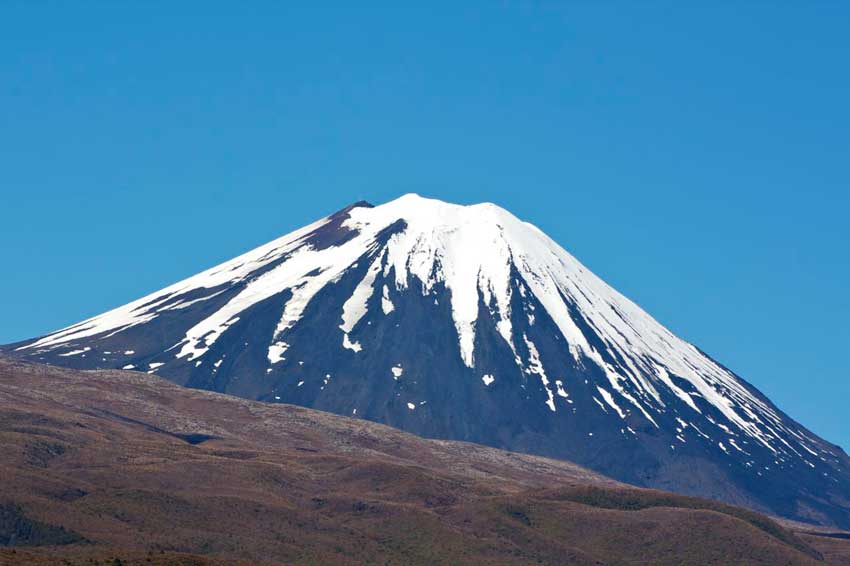
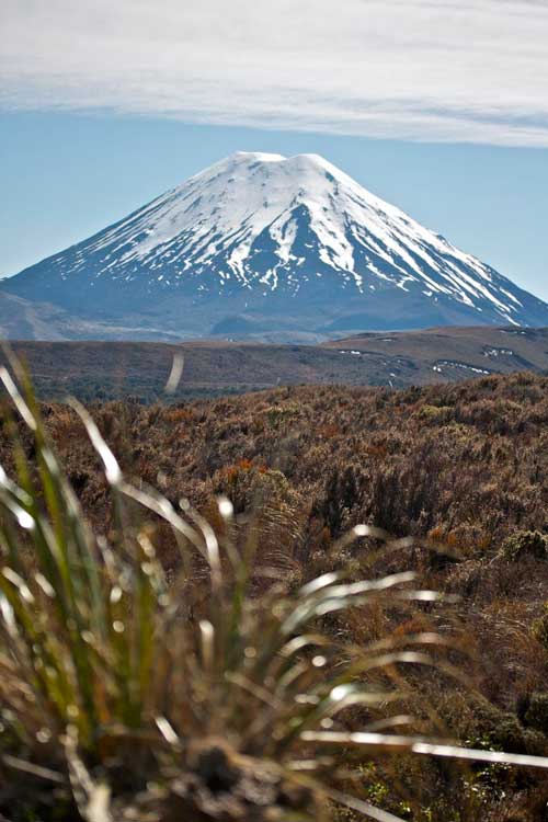
The trail starts off in the woodland at Whakapapa Village and starts climbing immediately. It then emerges out of the the trees and continues up the mountain to a turnaround point. It was a gorgeous morning with blue skies, no wind, the sun rising and I had the mountain to myself. As I emerged from the forest into the sunlight I was treated an absolutely stunning view of Mount Nguaruhoe in the distance. We hadn’t been able to see it yesterday as it had been shrouded in cloud so had driven up the slopes of Mount Ruapehu oblivious to its existence.

First View of Nguaruhoe
Now that I could see it in all its glory it was quite a sight – the perfect volcano. If you asked Morgan or any other 7 year old to draw a volcano, this is what they would draw. In fact even if you asked me, a 41 year old with a degree in geology to draw a volcano then this is what I’d draw. Nguaruhoe was resplendent in the morning sunlight, a perfectly conical mountain peak with a crater at the top and snow on its flanks. OK the snow capped top may be replaced by lava if Morgan were drawing it and it might have smoke spewing from the crater but it looked every part the volcano this morning. I stopped running to take a few photos and then stopped again on the way back down. I might never be here again and the running could wait while I got some photos for the album / weblog / book.

Nguaruhoe Sunrise
By the time I had stopped for photos and returned to the start point of the Ridge Trail it had only taken me 13 minutes, quite a bit less than the 1 hour walking time. I therefore decided to do another of the trails and this time picked the 1 hour 15 minute Silica Rapids Trail… As I set off I failed to notice that this wasn’t the return time, but the estimated 1 way time, so the entire trail was estimated to take 2.5 hours at walking pace. Again this trail soon pointed upwards as it snaked its way first through forest and then out onto open moorland, following the Whakapapanui River as it did so. Across raised boardwalks, over little bridges, past pools reflecting the mountains high above and onto more rugged mountain track. Again there were amazing views of the mountains, especially Nguaruhoe to the NE so I stopped several times for photos.

Mountain Reflection
-

- Nguaruhoe
-
- Nguaruhoe
-
- Nguaruhoe
The top of the Silica Rapids Trail is where the stream bed widens and the river spills out over a series of shallow terraces coated in creamy white deposits – the famous Silica Rapids. The trail actually continues on to The Bruce Road from here but I decided to retrace my steps across the mountain tracks rather than run down the road. I did of course stop a few more times to take in the views.

Silica Rapids
The 2.5 hour walking track took me about 30 minutes to run complete with stops so after 45 minutes of running I decided that was enough for the day and headed back to the camper for breakfast with Anna and Morgan. We were now into quite a routine in the camper. I would make a coffee after my early morning walk / run which would wake Anna and Morgan up, I’d then head off and do the washing up while they got up. By the time I returned it was time for me to get breakfast out. Breakfast was always cereal with some delicious New Zealand Yoghurt. I’d then make toast for everyone, either in the camper if we had an electric hookup, or in the communal kitchen if we didn’t. After that I’d do the washing up while Anna and Morgan packed the camper up ready to drive off. I was however still eating too much and not really feeling like a ‘World Championship’ Triathlete anymore – Never mind, this was supposed to be a holiday!

Our Route, Day 15
Hawhia Falls
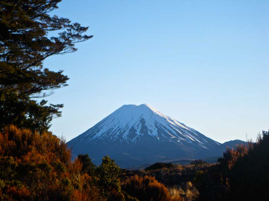
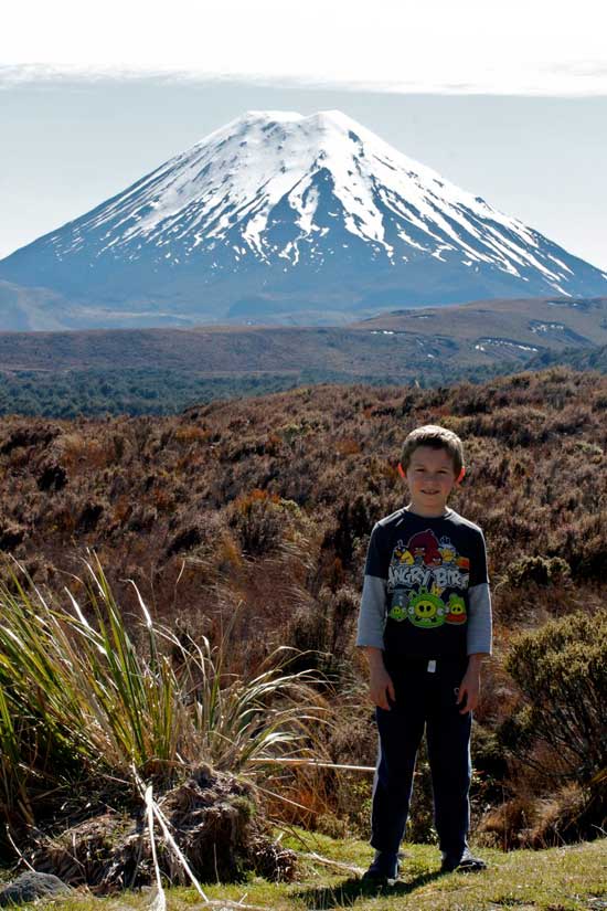
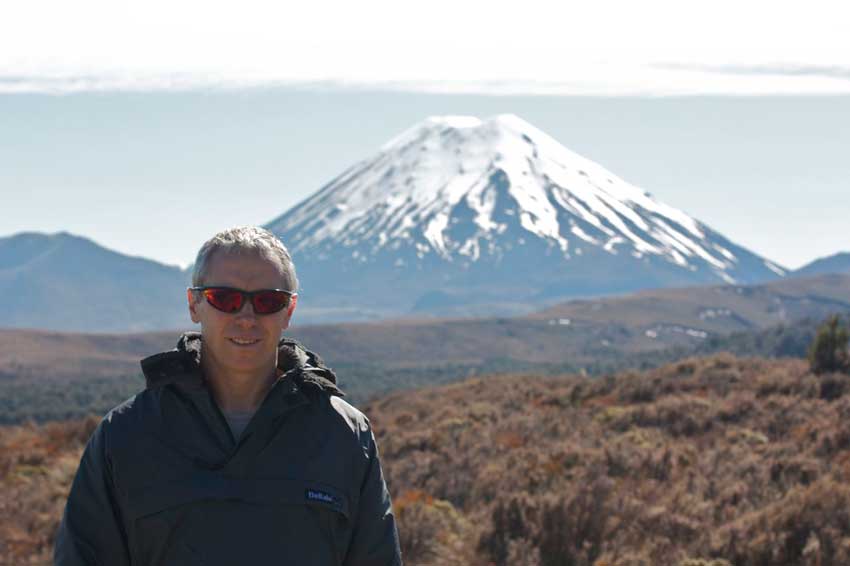
Todays plan was to do a little walk up in the mountains and then head off towards Lake Taupo and arrive there in time to meet my parents again who would also be arriving at Taupo later that day. We started off by driving just outside the campsite to The Chateau Hotel where there was a geocache. This was also Anna and Morgans first chance to see Mount Nguaruhoe. We found the geocache and both Anna and Morgan were suitably impressed by Nguaruhoe and the fact that it looked like a real volcano. We couldn’t resist but take some more photos of it from here.
-
- Nguaruhoe
-
- Morgan with Nguaruhoe
-
- Al with Nguaruhoe
We then took a little walk to Hawhia Falls and worked on a geocache on the way. It was a puzzle cache where we had to find clues to co-ordinates in order to move to the next set of co-ordinates. We found the answers easily but there were a few errors in the clues. It was all fairly obvious though so we were able to decipher what the person who had hid the cache meant. We weren’t however able to find the cache itself at the end, mainly because the co-ordinates were off and there were other people admiring the falls as well. It didn’t matter though as we were at the Hawhia Waterfall, the sun was shining, the birds were singing and it was a lovely, crisp, clear mountain day as we stood beside the river and watched the clear waters of the mountain stream tumble past.

Hawhia Falls

Hawhia Falls Plunge Pool

Clear Mountain Stream
Tongariro National Park
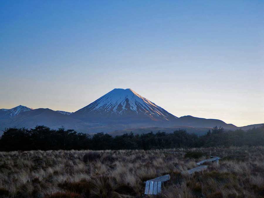
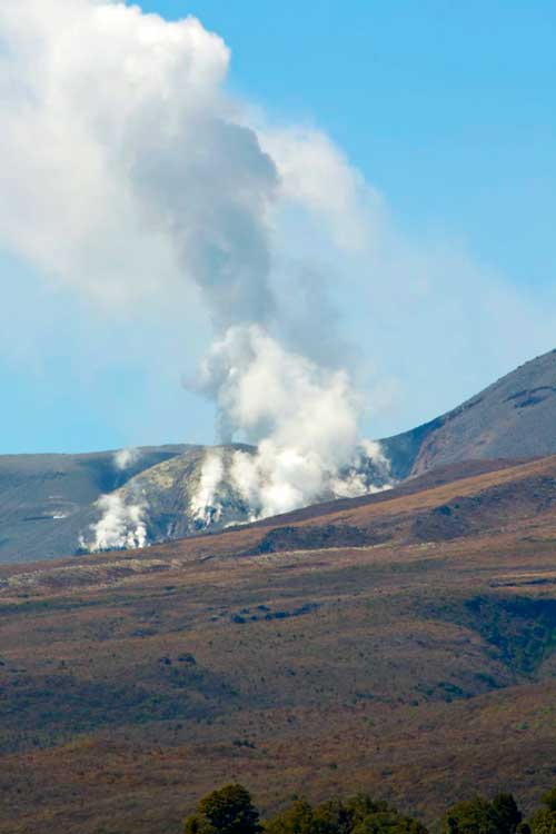
The drive to Taupo was dominated by the vistas of the Tongariro National Park. The first part of the drive had all three mountains that make up the interior of the Park to our right, Mount Ruapehu the largest with it extensive snow covered peak, Nguarohoe the cone shaped volcano and Mount Tongariro which had recently erupted and still had smoke and steam emanating from its flanks. We stopped along the road a couple of times for yet more photos from this vantage point and to soak in the scenery.

Panoramic Tongariro National Park

Smoking Tongariro Volcano
-
- Nguaruhoe
-
- Smoking Volcano
Lake Taupo
We also stopped for a walk to Lake Rotoaira which was nice, but not really that spectacular. The walk took us through the forest and down to the waters edge but we didn’t walk around the lake as Morgan wasn’t in the mood for walking today and it wasn’t worth trying to get him to. We stopped for lunch at a viewpoint overlooking Lake Taupo. At first Morgan though that lake Taupo was the little rectangular lake in the foreground, not the huge lake dominating the view – he thought that was the sea. Understandably he wasn’t impressed until we told him that the ‘sea’ was actually Lake Taupo – Now he was impressed.

Panoramic Lake Taupo
With a surface area of 238 sq mi, it is the largest lake by surface area in New Zealand. It has a perimeter of approximately 120 miles (although measuring the perimeter of a body of water isn’t really possible in my opinion!), and is 186 metres deep at its deepest point. It is drained by the Waikato River (New Zealand’s longest river), while its main tributaries are the Waitahanui River, the Tongariro River, and the Tauranga Taupo River. Lake Taupo lies in a caldera created by a supervolcanic eruption which occurred approximately 26,500 years ago. According to geological records, the volcano has erupted 28 times since then. The lake itself was formed by a volcanic eruption in 186AD. This enormous eruption sent ash into the atmosphere so high and so far that the Chinese and Romans recorded fiery red skies.
Today it was a place of peace and tranquility as we sat eating our picnic lunch looking out across it’s vast expanse of sparkling blue water in the afternoon sunshine.

Panoramic Lake Taupo

Anna & Morgan Overlooking Lake Taupo
After lunch we drove along the east shore of the lake towards the town of Taupo. As we approached Taupo we started looking out for Quest Apartments where my parents would be staying that evening. We found them straight away so stopped to leave them a message and at the same time asked the receptionist how to find the free campsite we were looking for. She was very helpful, not only directing us to the campsite, but also several other options, pointing out a few places to visit and providing us with a very useful map of the town. Suitably informed we set off to explore Taupo.
Huka Falls & The Waikato River
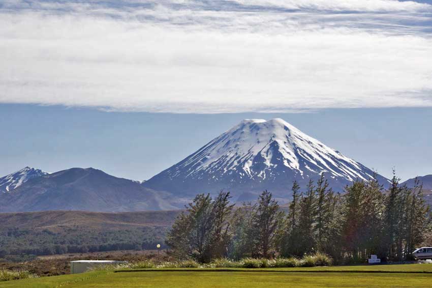
First stop was to be Huka Falls but we got distracted by a viewpoint on the way so stopped there to take in the views of Taupo, the lake and in the distance the snow-capped mountains of the Tongariro National Park. – Yes, these mountains were still visible and still looked impressive on the horizon.

Taupo Panorama

The Mountains from Taupo
We then went to Huka Falls, a set of waterfalls on the Waikato River that drains Lake Taupo. There is a little visitor centre here and a car park that leads you across a bridge with the Waikato River thundering below. At this point you are upstream from the Huka Falls, where the Waikato River narrows from approximately 100 metres across into a narrow canyon only 15 metres across. The turquoise blue waters surge through this canyon creating an impressive display. The volume of water flowing through often approaches 220,000 litres per second, although the flowrate is actually regulated by the company “Mighty River Power” through the Taupo Control Gates as part of their hydro system planning. There is a small set of waterfalls dropping over about 8 metres into this canyon, but the most impressive, final stage of the falls is an 11 metre drop into a huge plunge pool. The drop is technically six metres but the water flow raises the level to 11m. The falls themselves are impressive, as is the amount of water rushing over and the power of that water, but the main thing you notice is the intense blue of the water as it powers its way through the canyon and over the falls.

Huka Falls Canyon

Huka Falls
We didn’t stop long here but continued on, stopping at a viewpoint overlooking the falls and then investigating a free campsite by the rivers edge. The guidebook had said it had free camping and river swimming and we had hoped to camp here for the night so that I could have a proper swim in the river in the morning. The river though was the Waikato and it was flowing at a ridiculous rate, far too fast to swim against and worse still, it was upstream of the Huka Falls – Probably not advisable to swim there then!

Anna at Huka Falls
Bathing in the Hot Water River
The road past Huka Falls and out of Taupo is lined with tourist attractions and activities. From Jet Boat rides to Helicopter Rides, Mountain Biking Trails, Volcanic Activity Centres, a Honey Farm and even a Prawn Farm and then onto a geothermal plant. We couldn’t visit them all but now that we’d driven past them we had an idea of what was on offer and what we would return to tomorrow. For now we were checking out campsites and off to visit a hot water river. The Top10 campsite was a little over the top for us – too large, too many facilities and too expensive. The hot water river is a little off the tourist trail in the Thermal Spa Park. It seems to be a place frequented by locals and is simply a small stream of steaming hot water that cascades down a little hillside and into the Waikato River.
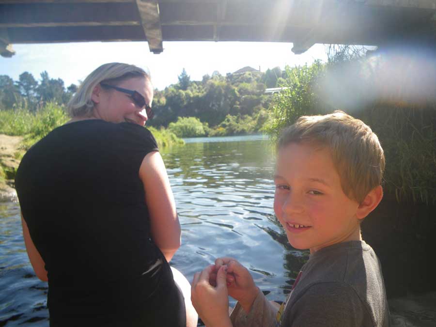
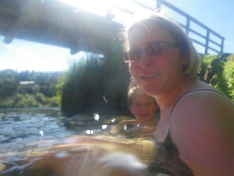
Access to the Hot River is along a pleasant little walk from the car park down the grassy hillside towards the Waikato River. There are other trails here, both walking trails and Mountain Bike Trails that lead to Huka Falls, the Aratiatia Rapids and other spots along the river. The Hot River has a little bridge over it and there were people jumping from the bridge and soaking in the pools below. We went a little upstream at first to a small secluded pool but soon discovered that it was far too hot here so joined the others where the cold waters of the Waikato mix with this tributary to make the water bearable.
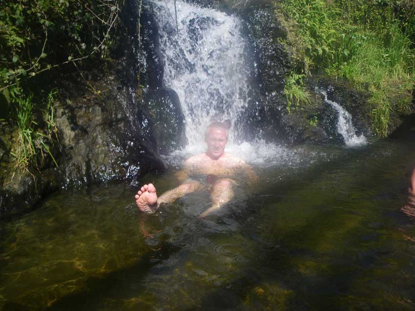
We were soon in our swimming kit and bathing in the mineral rich waters. I obviously joined the local kids in jumping off the bridge too!
-
- Anna & Morgan in the Hot River
-
- Anna & Morgan in the Hot River
-
- Al in the Hot River

Morgan in the Hot River – Oooh, ooh, It’s too hot!
Taupo
After soaking here for a while we got dried and dressed, had an ice cream from the freezer in the camper van and then headed off to the other side of town in search of another campsite. This one was perfect. The Great Lake Campsite had all the amenities of the Top10 Site but was much friendlier and much quieter and although it still cost $45 for the night was much cheaper than the Top10 site as well. We then went into Taupo and found my parents.
Taupo itself if a very touristy town. It has a population of around 32,000 but this more than doubles to 65,00 during the peak summer months due to the influx of tourists. It was quiet at the moment though as we were a little early in the year for summer so I think we caught it at a perfect time. The weather was certainly very summery but we managed to avoid the crowds. It has the feel of a mediterranean coastal resort to me with lots of bars and restaurants and al fresco dining in the evening. Despite this well-to-do resort feeling it doesn’t seem to have the snobby, ‘my yacht is better than yours’ feel so was a pleasant place to while away the evening. We had dinner in a surfy style cafe / restaurant and then walked along the front as the night closed in.

Taupo by Night
After coffee with my parents at their very nice apartment we headed off to our campsite and settled down for the night.

Lake Taupo Campsite


Great blog posts of NZ Al, it’s making me want to do another tour of NZ.
If you had timed your trip a few weeks later, you would of seen this!
http://www.nzherald.co.nz/nz/news/article.cfm?c_id=1&objectid=10849028
Ooh, exciting! Mt Tongariro did erupt a few weeks before we went out there, and it was smaking quite a bit from one of the craters on its flanks whilst we were there. It would have been good to have seen a full scale eruption though – The sort of thing you really want to see as a geologist – albeit from a safe distance.
Al.