Wales Coast Path Run – Swansea to Oxwich
Coast Path Vital Stats
Swansea to Oxwich
- Distance: 18.31 miles
- Elevation Gain Today: 515m
- Highest Elevation: 84m
- Time: 3:36:57
- Av. Pace: 11:51 mins/mile
- Calories: 1671
Totals to Date
- Total Distance: 767.96 miles
- Total Time: 141:55:34
- Total Elevation Gain: 22185
- Total Calories: 69725
- Distance to go: 324 miles
I should probably start this Wales Coast Path Run project post with the usual excuses. This is the first time I’ve continued with my run to circumnavigate Wales since October when I ran from Port Talbot to Swansea. Various things have conspired to get in the way.
- Cyclo-cross season saw me driving to South Wales on a Sunday for a number of weekends. I didn’t then feel like driving back down again on the Monday or Tuesday to continue my Coast Path run. Really what I should have done was to stay overnight in the van after the cyclo-cross race and then continue with the run on Monday. That would have made sense for so many reasons but it would also have meant leaving my bikes unattended on the back of the van while I ran along the coast which I wasn’t comfortable doing.
- There were surf ski races in North Wales on other weekends. Again, after a long drive to North Wales and back on the Sunday it seemed silly to drive all the way to South Wales the following day.
- Christmas and all the things associated with it got in the way for a few weeks.
- A sore knee and a sore back scuppered my plans for a couple of weeks.
- Kilimanjaro preparations and the trip itself became my focus after that which also prevented me from getting out on the coast path.
- We then had a succession of storms that put me off as well. I’m not usually put off by the weather but as the next stage of the run would take me out onto the Gower and past some of the best beaches in Wales such as Three Cliffs Bay I wanted to do it on a nice day just for the photos.
Finally, after months away from the Coast Path things looked good for Tuesday this week. The rain was supposed to ease off, the sun was due to make an appearance and I had the time and motivation to carry on around Wales. The only problem was that I hadn’t run any further than about 10km (6 miles) for months, so suddenly heading off for a 20 mile run might be a bit of an undertaking. I reviewed the routes, reviewed the bus timetables and decided that I could run from Swansea (where I finished last time) to Oxwich Bay. That would be 16 miles. There was car parking at Oxwich. There was also a bus stop about a mile from the car park that would take me right into the bus station in Swansea – well, to be precise the bus stop itself wouldn’t take me there but a bus that would stop there would! So, that was the plan.
I set off a 7am for the 2½ drive to Oxwich. There was a bit of rain on the way there but it started to dry up. Parking was free and easy so I put on my running shoes and ran up to the bus stop.
When I got there the times on the timetable were quite different to those I’d seen online and seemed to suggest that I had to wait over two hours for a bus. The bus stop itself was on a little side road as well and didn’t look quite right so I decided to jog along the main road to the next bus stop and see what it said there. As I did so, a delivery van pulled out of the side street opposite so I stuck my thumb out on the off-chance of getting a lift into Swansea. Amazingly they stopped and said they were heading in that direction for about 4 miles so would take me that far. That was nice of them!
I got out of the van a little further along the main road and decided to walk to the next bus stop. Although it was the main road into Swansea it was very quiet and I didn’t see another car for a while. About ¼ of a mile along the road I spotted a bus stop and as I did a Range Rover came along the road behind me. I thought I try my luck hitching again and once again the driver pulled over and was going into Swansea. I jumped in and managed to get a lift to Uplands, about a mile from where I was supposed to start my run. The driver was a runner himself and had assumed I’d sustained an injury and needed a lift home! He was quite happy to give me a lift though and we chatted a bit about running and triathlon as we headed into Swansea. He also spotted his wife driving in the opposite direction at one point and she no doubt wondered who the strange man sat next to him was!
He dropped me in uplands and I had a short run through the streets of Swansea to the bus station and from there retraced my steps out to the sea front and the long sweeping promenade around Swansea Bay. I turned right and was now back on the Coast Path once again.
Swansea Bay
The sun was out now and the prom was busy with people strolling, running, walking dogs or cycling. There was a strong headwind but it was looking as though it would be a nice day.
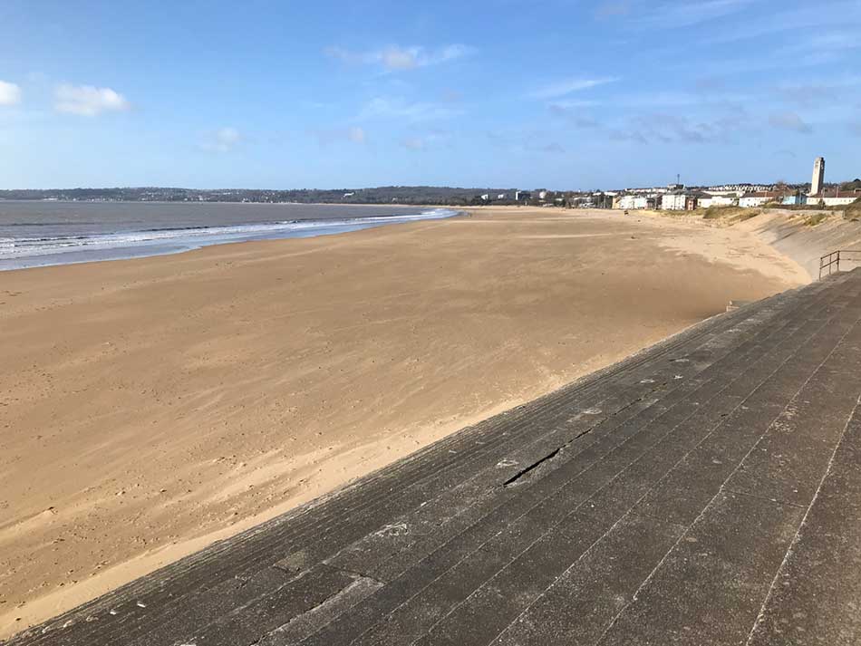
The Mumbles headland could be seen at the far end of the bay many miles away. That was my first destination for the day as I set off along the long flat, wide promenade. That was about it really for the next 6 miles. The prom was divided into two sides by a white line. One side for walkers (and runners) the other for cyclists and I simply ran along it at a steady pace for 6 miles weaving in and out of the other pedestrians but never straying far from the line. There was little of note really. The sea with little whitecaps disturbing its surface and a swell rolling into the beach was to my left. The busy road was to my right. The concrete prom stretched for miles ahead of me gradually sweeping it’s way around to The Mumbles. The flat, easy surface probably meant that I started out a little too fast for what would be a long run.
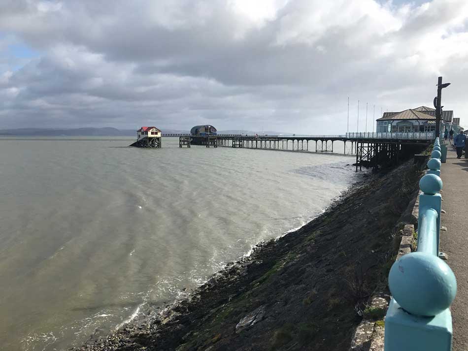
Eventually I reached the end of the prom and came upon the piers that led to the Mumbles Lifeboat Stations. here I turned right up a flight of uneven steps and out onto the headland.
South Gower Clifftop Path
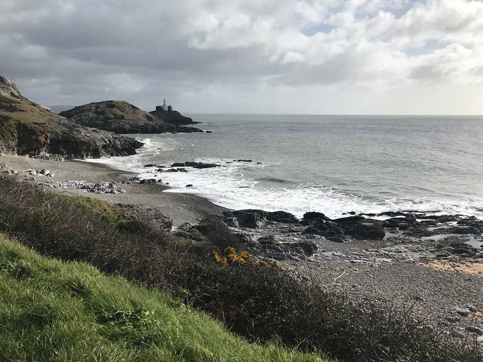
Over the top of the headland I went with the little beach of Bracelet bay being pounded with waves below me. I ran through the car park and then past Limeslade Bay and out onto what looked like a new section of fully accessible concrete coast path. This path ran for quite a way, hugging the coastline and snaking around the various headlands undulating up and over the rocky coast as it did so. It all looked very new and to the sides the vegetation had yet to grow back. Once it has bedded in a little it’ll be a lovely section of coast path that will be accessible even to wheelchair users – although some parts of it were quite steep. Today it was windswept but the sun was shining and there were plenty of people out walking along various sections of it. Most couldn’t hear me coming as the wind was blowing into our faces so I jumped onto the mud to the side of the path now and then to run around people blocking the path.
I was jogging along at a nice steady pace and soon came down off the cliffs and into Langland.
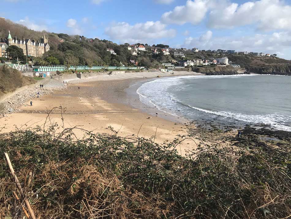
Langland and Caswell
Langland was looking nice. There was a decent swell rolling into the nearside of the beach and waves were crashing onto the rocks, sending spray high into the air. Little rainbows were forming in the spray as the sun shone through it. Behind the sandy beach the prom was backed by a long row of neat green and white beach huts as people strolled up and down. The prom itself was sheltered from the wind so it was quite warm along here in the sunshine. At the far end of the bay I headed up onto the rocky coast once more and out onto the headland. The new concrete ‘accessible path’ continued as I once again started to weave my way up and down the rocky coast.
By now, what had been close to ten miles of concrete was beginning to take it’s toll. I had trail running shoes on as I had expected plenty of mud but the lack of cushioning wasn’t ideal. I had some hot spots on my feet already and started looking for any bit of softer surface to run on whenever I could.
After a steep climb I was faced with a few steps down the other side and into Caswell Bay. (Maybe it isn;t quite so wheel-chair friendly after all). Here the surf was a little better and there were a few people out catching waves. The coast path took me around the back of some beach-side buildings and then down across the pebbles and onto the sands. It then took me up some steep steps and back out onto the headlands. I was now finally off the tarmac and onto slightly more challenging surfaces.


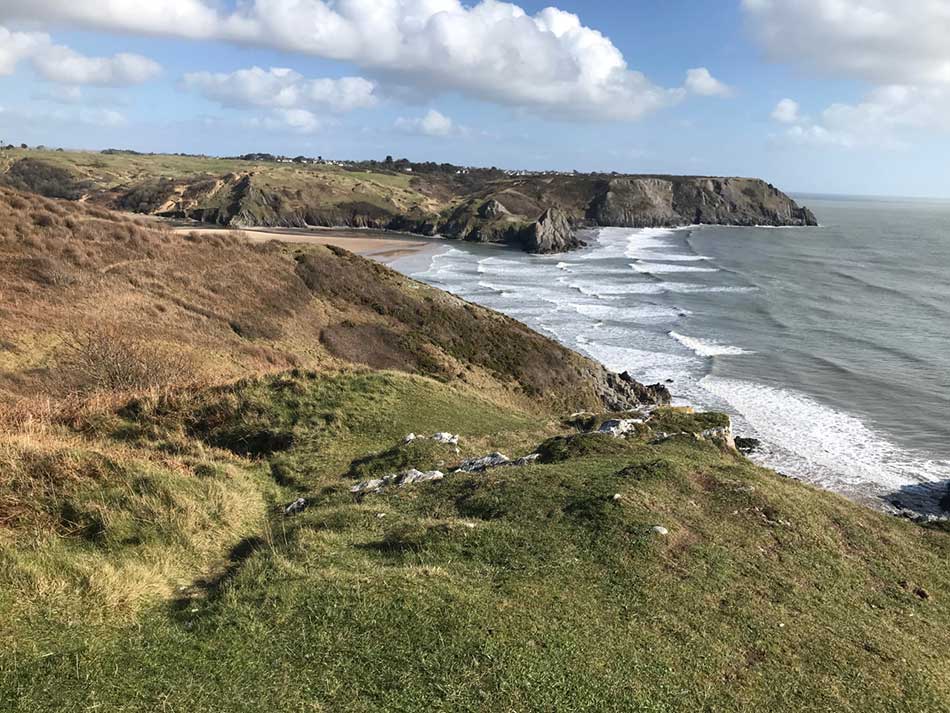
Pwlldu and Three Cliffs Bay
The path weaved its way up and down the cliffs with some steep climbs and descents. Things were now quite muddy in places and in others there were steep rocky sections with trip hazards galore. I jumped over muddy puddles, clambered up the rocks and teetered my way down the other side.
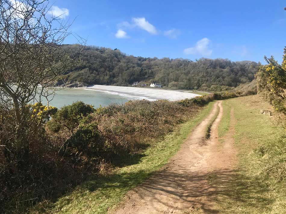
I came upon the sheltered beach of Pwlldu and here the path took me around the back of the beach and over a little river before heading steeply up through a woodland. I think I went a little too far around the bay in fact and ended up on a very steep, very muddy little detour which had me on all fours scrambling up the steep hillside grabbing trees to stop myself sliding back down. This slowed my progress somewhat but I was soon heading back on myself to join the proper path where the going was easier. This took me up onto the windswept Pwlldu Head.
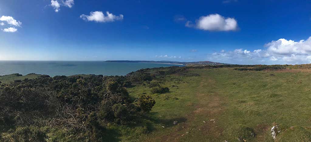
The path now stayed high up on the cliffs for a few miles with nice views out along the Gower Peninsula ahead of me and back from where I had come.


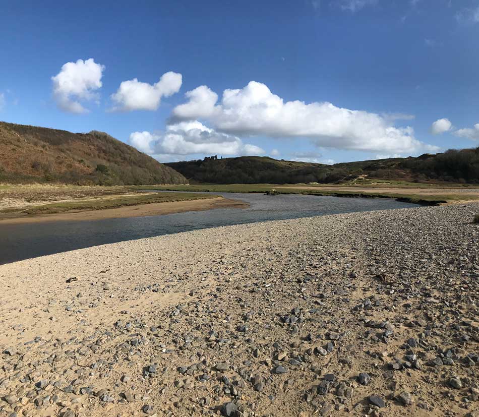
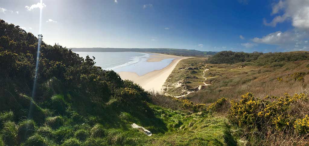
There were still a few undulations as the muddy path followed alongside the clifftop road. The path weaved its way in and out of gorse bushes on the open cliff top with horse hoof prints in the mud. I jumped over or weaved around the more muddy patches and continued to plod on heading ever westwards. There were cottages lining the inland side of the road and some nice houses too. Eventually I headed back out onto more exposed clifftops, away from the houses and the quiet road. Soon, the distinctive cliffs of Three Cliffs bay could be seen ahead of me. This beach always get listed in the top UK beaches and is a postcard favourite so I was glad that the sun was still shining and that it would look good in the photos.


The path took me to plenty of little viewpoints so that it could be seen from all angles. After weaving around on the clifftops I was soon heading down over soft sand to the beach itself. Here I ran out onto the pebbly spit that separates the river from the beach and stopped to empty the sand out of my shoes. Behind me Pennard Castle could be seen perched atop the hill.
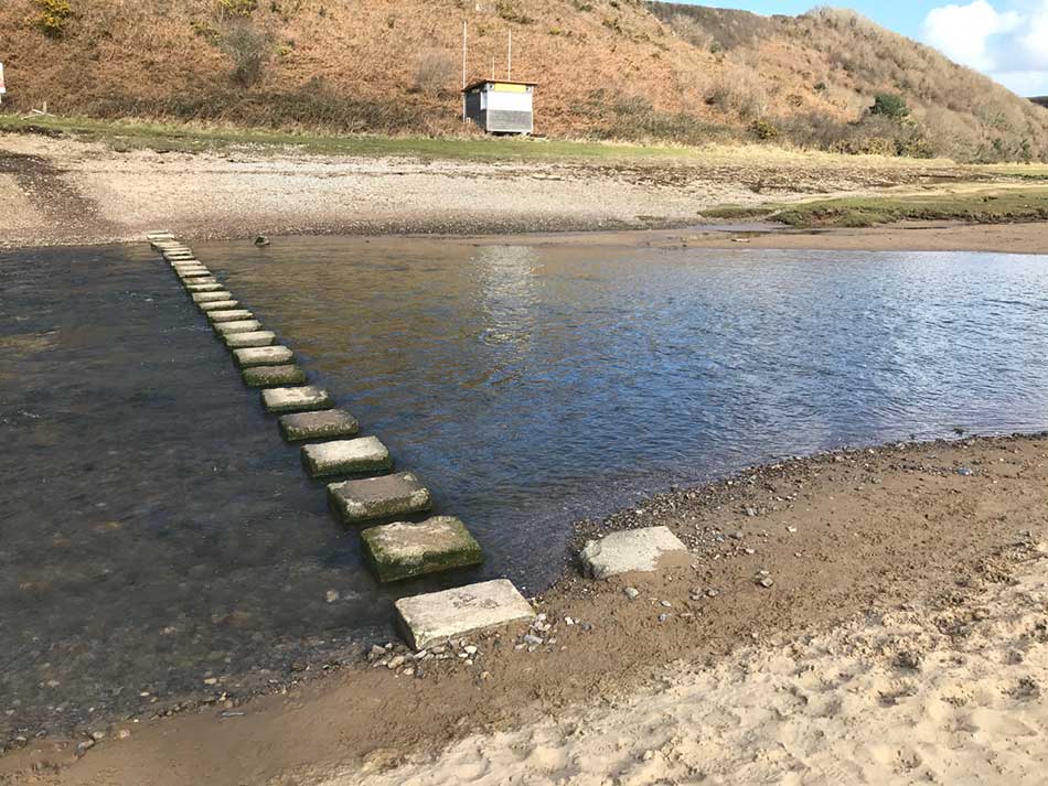
Next there was a stepping stone crossing of the river and then some steep climbs up over soft sand-dunes.
That wasn’t quite the end of it though as the path descended through the sand to the beach again before climbing once more through the dunes of Penmaen Burrows. Here I emerged out onto the headland overlooking Three Cliffs bay once again and continued on my way into the wind through gorse covered clifftops.
Oxwixch Bay
The path now headed up and down some steep hills behind Tor Bay and then entered more hilly paths through Nicholaston Woods. My legs were tiring by now and I was starting to walk some of the steeper sections. Occasionally views would open up at the tops of the hills to give me a vista of Oxwich Bay with it’s complex of dunes behind it.
Eventually I descended out of the woodlands and down to a bridge across the river.


Here I entered the dunes proper and weaved my way along the sandy tracks heading towards Oxwich. A few parts were completely flooded forcing me to make detours around the ponds. It wasn’t clear which of the tracks were the official coast path but I headed in the general direction towards the village of Oxwich. I was now walking as much as I was running but progress was still good and I didn’t have far to go. It would probably have been easier to head out onto the beach and run along the sands but I stayed in the dunes and eventually made it to the car park where the car was waiting for me.
The run had been a little longer than expected thanks to the extra couple of miles at the start but at 18.31 miles it had been a good day. It was of course not very fast but that’s to be expected over such terrain and I do stop to take photos and take in the views now and then. It was good to get back out onto ‘proper’ coast path after what had been quite a few miles of fairly urban running through South Wales. ‘Proper’ coast path with it’s rugged surfaces, steep ups and down, sands, pebbles, rocks, mud and the constant weaving this way and that may results in slower times but it’s much more fun and the photos are better too. I wonder how long it’ll be before I do the next stretch. Hopefully I’ll be up for it next week but we’ll have to see.
Discover more from A Simple Life of Luxury
Subscribe to get the latest posts sent to your email.
3 Responses
-
[…] making an attempt to continue with my Wales Coast Path Run a few weeks ago my plans to continue it over the Spring were scuppered by the Coronavirus Lockdown. Typically, […]


I wonder why we’ve never been to those beaches as they look lovely and are closer than Devon and Cornwall ? Maybe this summer !
Not sure I’m that happy about you hitch hiking though x
There’s loads more beaches on The Gower too…. watch this space! 🙂