Summit Bagging in the Mist
Having been out of action for a week or so thanks to a cold that went to my chest, I was dying to get out in the fresh air doing something exciting. I went for a short run on Sunday that was slow and quite a struggle but it didn’t set me back at all so I decided a walk / trot in the hills was on the cards for Monday. Being out in the hills somewhere I don’t know rather than running familiar trails would mean that I wouldn’t be worried about my pace and could decide whether it was a walk or a run whilst I was there. I thought I’d try to bag a few summits that I haven’t been to before as well so planned a little route that looked good
The Surprise of all Surprises
When I have such things planned I sometimes ask Morgan if he’d like to join me. The answer is always a resounding ‘no’ but I keep asking just for fun anyway. This time he said yes and sounded quite enthusiastic about it too. He was soon asking questions about where we were going, how high the summits were, how long it would take, what he’d need to wear etc etc. This was quite a turn-up for the books but was fine by me and should make it a fun day in the hills. It’s also safer to have company out there rather than be in the middle of nowhere all on my own.
I revised my start time a little so that Morgan wouldn’t have to get up too early and I packed a rucksack for him too. Although, when talking about timings he surprised me again by saying he’d rather leave early so that we weren’t too late back. Who is this boy?? What’s more when I was sorting out some suitable shoes for him he said he’d go with the trainers rather than boots so that we could run it rather than walk it (as long as I was carrying the rucksack!)
A Grey Dawn
Things took a bit of a turn when I got up on Monday morning to dark skies, clouds over the hills and light rain. The light rain became heavy rain and before I knew it Morgan had wimped out!! Oh well, he seemed enthused by the idea of a day in the hills for a little while, but I was back to day out there on my own.
I was soon driving through heavy rain and puddles. I had a few chores to do on the way but pulled up at the top of the Brigands Pass on the A470 in North Wales just before 10am. It was a little breezy here, the hilltops were shrouded in cloud and it was still raining. It wasn’t cold though and with what looked like a tough climb to start the day I decided against the waterproofs for now.
Up to the Top
The initial climb was indeed a tough one. I didn’t even contemplate running any of it as it was a steep slog straight up the side of the hill. I was soon way above the road and looking down directly onto the roof of the van. As I climbed higher the clouds closed in around me and I could no longer see the road or the van. In fact, I couldn’t see anything but I was following a fence line and was heading upwards so I continued on.
It didn’t take that long and I was soon at the top. There was nothing to be seen in the clouds though and no references for where I was going next. I couldn’t even really see which way was up or down now that I was on more undulating ground. I relied on the fencelines and my compass to head in the right direction and now and then struck out for what I hoped was the summit of a hill.
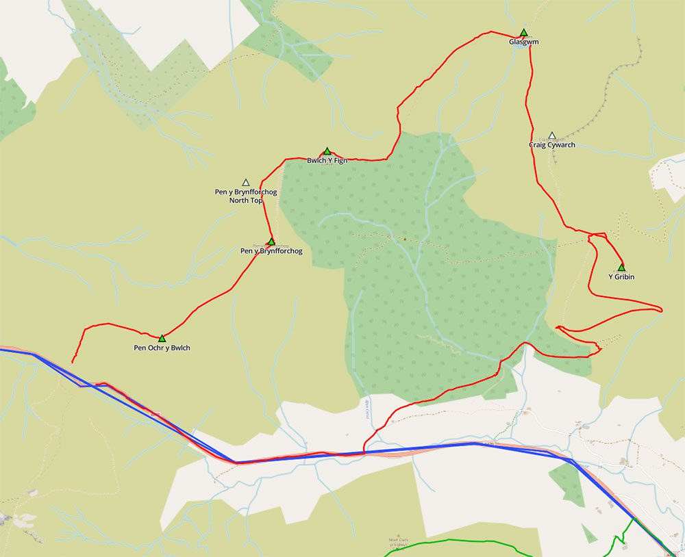
The fences certainly helped with the navigating as I made my way across the top of what is essentially a little ridge, ticking off the ‘summits’ of Pen Ochr y Bwlch, Pen y Brynfforchog and Bwlch Y Fign as I went. Unfortunately, I managed to miss a little summit that I didn’t realise was there. Had I known (or been able to see) I would have made the slight detour east to bag ‘Pen y Brynfforchig North Top’ too. Maybe next time I’ll look up the summits on the summitbag.com website first and mark them on the map and then aim to find all of them as if I were orienteering. I did miss another a little later in the day at Craig Cywarch. Again, I didn’t really know it was there but even if I had I may have missed this one out today as it was dangerously close to a precipitous cliff which probably wasn’t a place I wanted to be with visibility the way it was.
You can see the ones I missed marked as white triangles on the map below.
Through the Rain
It was now raining quite a bit but I felt comfortable with just my thin merino wool base layer and shorts on so I didn’t stop to don my waterproofs. I was now skirting around the northern edge of a conifer plantation as the ground undulated up and down little rocky sections and then crossed small boggy hollows. I was jogging where I could and making good progress with the odd stop there and there to check the map and compass and make sure I knew where I was.
I wondered what Morgan would have thought if it had he joined me – I’m not sure he would have enjoyed it necessarily as there wasn’t much to see, just lots of mist and murk. Maybe it was a good thing he changed his mind as it may have put him off forever!
I was heading to the high point for the day and the summit of Glasgwm. I still couldn’t see anything around me and was just wondering how I’d find the actual summit. Then suddenly, a few feet in front of me was a large and impressive cairn. I hadn’t really realised the visibility was quite that low. I stopped, took a few steps back and it was gone again. A few steps forward once again and I could reach out and touch it. Visibility here was literally about 3 feet!!
I’d found the summit though so headed back down the hill somewhat to find the lake. Again, I must have ran about 10 feet away from it just now but hadn’t seen it. I now found it, thought briefly that a quick dip would be fun but probably not sensible, so instead double-checked my compass, double-checked the map and set off running cross-country with no fence to follow. It wasn’t far with nothing other than a compass for reference as I was aiming for another fenceline a few hundred yards away. The fence took a bit of a dogleg where I intended to join it though and if I was off by a few degrees I’d miss it and could be headed for the steep cliffs of Craig Cywarch and certain death!! I was pretty confident in my bearing though and did soon pick up a little track to follow. I was also aware of the proximity of the cliffs so kept my wits about me just in case.
I soon found the fence right at the dogleg I was aiming for and now followed it and a well-defined path down a steep slope that took me along the top of the cliffs. I then came to a saddle where there were several paths all going in different directions. As I was checking the map to make sure I followed the correct one I noticed that the summit of Y Gribin was just up ahead of me. So, rather than follow the path I had intended I made a quick detour to another summit and then retraced my steps to the junction where I picked up my planned trail. This soon became a wide double track that zig-zagged its way down into another valley.
Back to the Bottom
I didn’t have to descend far before the mist and murk started to clear and I could see the valley laid out before me. I hadn’t taken any photos up until now as there had been literally nothing to see. I took a few of the valley and then continued to descend, stopping partway down for a spot of lunch.
From my lunchtime vantage point I could see the Red Bull Hardline mountain bike course and the impressive road gap jump. I continued down into the forest and then passed right under the road-gap jump itself. I had a good look at it and decided it wasn’t for me!!! The people who ride this course are nuts!
From here I headed to the road and then had a fairly nasty jog and walk back along the A470 to the van. I couldn’t see a suitable alternative that took me off the road and with no verge and no pavement it wasn’t the nicest of places to be walking. The mist soon closed back in around me and by the top it was pouring with rain again.
I jumped into the van, changed out of my soggy clothes and had a nice easy drive home. It was only 3 hours of jogging / walking and I covered just under 9.5 miles but it felt as though I’d done quite a bit. Let’s hope we get a nicer day soon and Morgan can actually join me on an adventure in the hills.


1 Response
[…] and even highlight the risks of landslides and other potential dangers. So, while you’re on a trail or a hiking trip, it is essential to look for these […]