Llwyngwril to Talybont Coast Path Run
Coast Path Vital Stats
Llywngwril to Talybont
- Distance: 14.53 miles
- Elevation Gain Today: 454m
- Highest Elevation: 313m
- Time: 2:26:58
- Av. Pace: 10:07 mins/mile
- Av. Heart Rate:
- Max Heart Rate:
- Calories: 1583
Totals to Date
- Total Distance Completed: 77.27 miles
- Total Time: 13:34:56
- Total Elevation Gain: 2904m
- Total Calories: 8067
- Distance to go: 801 miles
The plan for Saturday’s Coast Path Run was to run the 12 miles or so from Llywngwril to Talybont, stage 5 of my Coast Path run project and it didn’t look like too difficult a section. I changed my plan a bit though as usually I drive to the start point, run to the end and then get the train back to where I started. That can mean that I’m either rushing for the train at the end of my run or waiting a long time for the next train. So instead I decided to drive to the end point in time for the train back to the start point and then run back to my car. Hopefully that would mean less waiting around and with no time constraints on the run I could just enjoy it more.
I’m not sure what I will do once I reach Pwllheli though as that is the end of the Cambrian Coast trainline which has been quite handy for the section north of Aberdovey as it has stops every few miles and as it’s name implies it follows the coast and therefore follows the Wales Coast Path.
Early Morning Ride
As in past weeks, I started the day with a Turbo Trainer session. I had to start earlier on Saturday though simply because the further I get away from home on my Coast Path run project, the more travelling time is involved, so the earlier I need to start. I may have to re-think my turbo trainer session on a Saturday morning soon. I managed to fit one in though and it wasn’t an easy ride either. It was a TrainerRoad session called Clark which totalled 90 minutes and consisted of 6×8-minute efforts between 88-94% FTP directly preceded by a 12-second round of big gear, high-force stomps with 3 minutes of recovery separating the intervals. Lots of sweet spot work in other words with a few sprints thrown in for good measure.
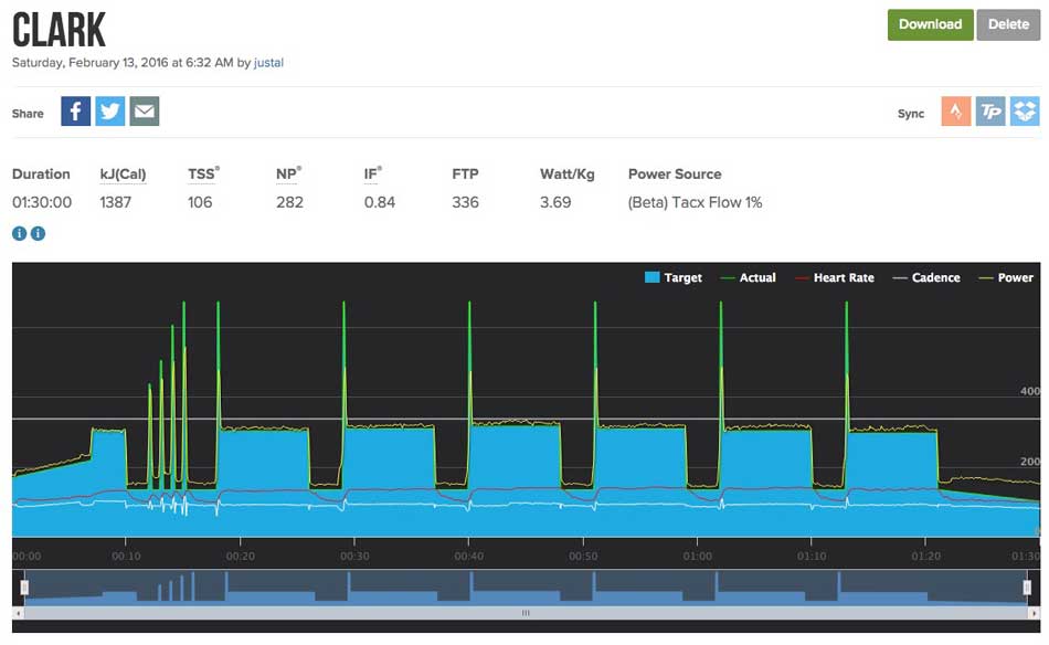
Clark
I felt good though, completed it had some breakfast and got ready to go whilst Anna popped out to the vets with the cat.
Coast Path Run
The drive north to Talybont was fine. It was a dry but cloudy day and there was some glimpses of snow on top of Cadair Idris. Only glimpses though as the summits were shrouded in cloud. It didn’t take as long as I expected so I arrived in Talybont about 50 minutes before the train got there. At least I could wait in the relative warmth and comfort of the car, listening to podcasts while I waited rather than having to wait in the cold after my run. The train itself was a little late so I did get a bit cold waiting on the station but warmed up again once sat on the train.
The conductor on the train looked a little surprised when I got on at Talybont and wanted a ticket to Llywngwril. I guess most people who get on at one of these tiny, out of the way stations are going to somewhere a little larger, going from one tiny out of the way station to another tiny out of the way station is a little odd I suppose. The train headed off first to Barmouth and then across the Mawddach Estuary bridge before teetering along the coast perched right above the waters of Cardigan bay.
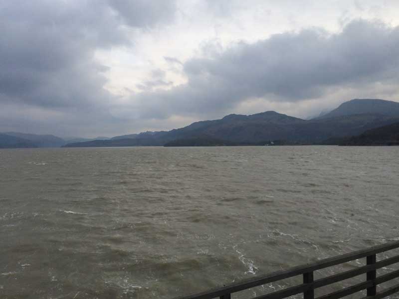
Train across the Mawddach
The train took about ½ an hour to get to Llwyngwril where I was surprised to see quite a few people waiting to get on the train. The yarn-bombers that inhabit Llwyngwril had been out on force and the station was covered in knitted love-hearts and roses for Valentines Day.
Llwyngwril to Talybont
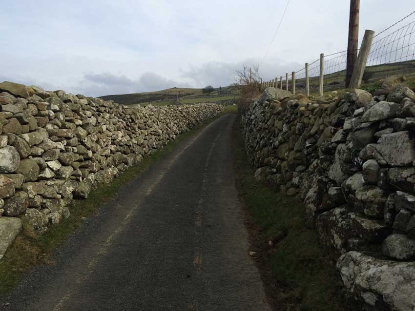
I put my rucksack on and started running up towards the main road where I could join the Wales Coast Path. From Llwyngwril the Coast Path immediately heads uphill, steeply at times too. First on tarmac between the dry stone walls of this area, then onto a gravelly track and finally out onto the grass, rocks and muds of the open hillside. Views along the coast open up before you here with Llywngwril far below and the Mawddach Estuary and Barmouth in the distance.
-

- Dry Stone Walls
-
- Llwyngwril Coastline
-
- Stone Walls
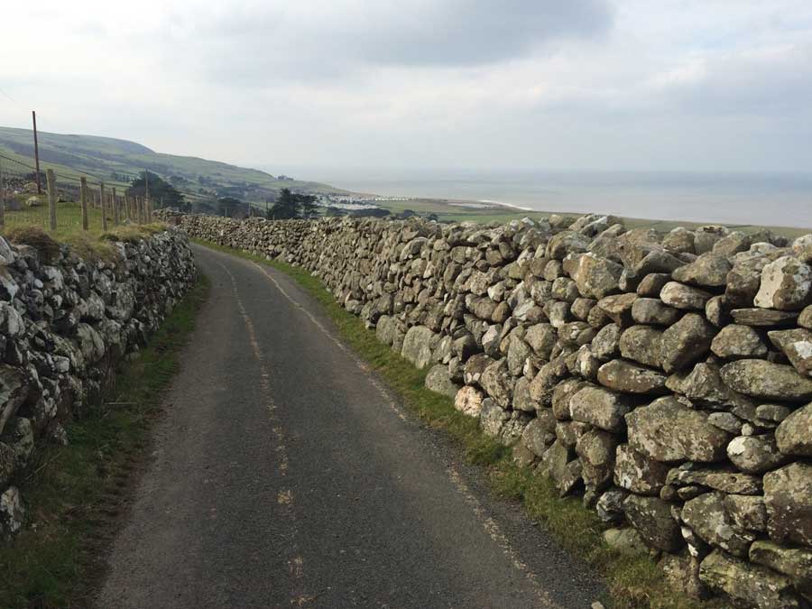
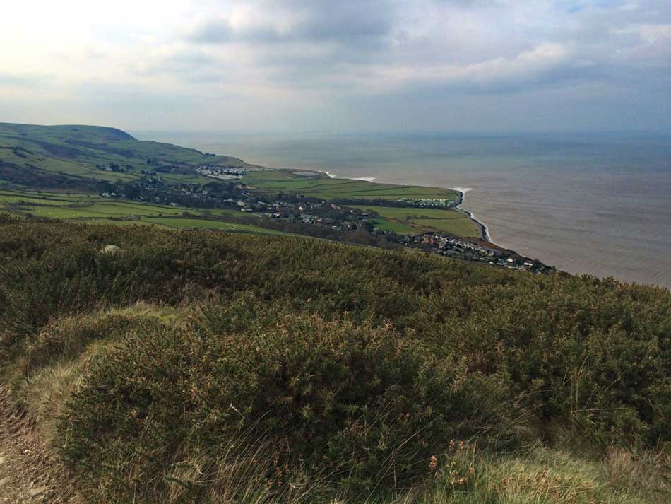
The coast path actually heads quite a way inland here, working its way ever higher into the hills crossing streams and passing farmers out eating their packed lunches next to their quad bikes and a pen full of sheep. It feels as though you could be going the wrong way up here as you head ever further inland with few Coast Path signs to reassure you. The sights north across the Mawddach Estuary are well worth the effort though and afford a perfect view of the next stages of the Coast Path laid out before you.
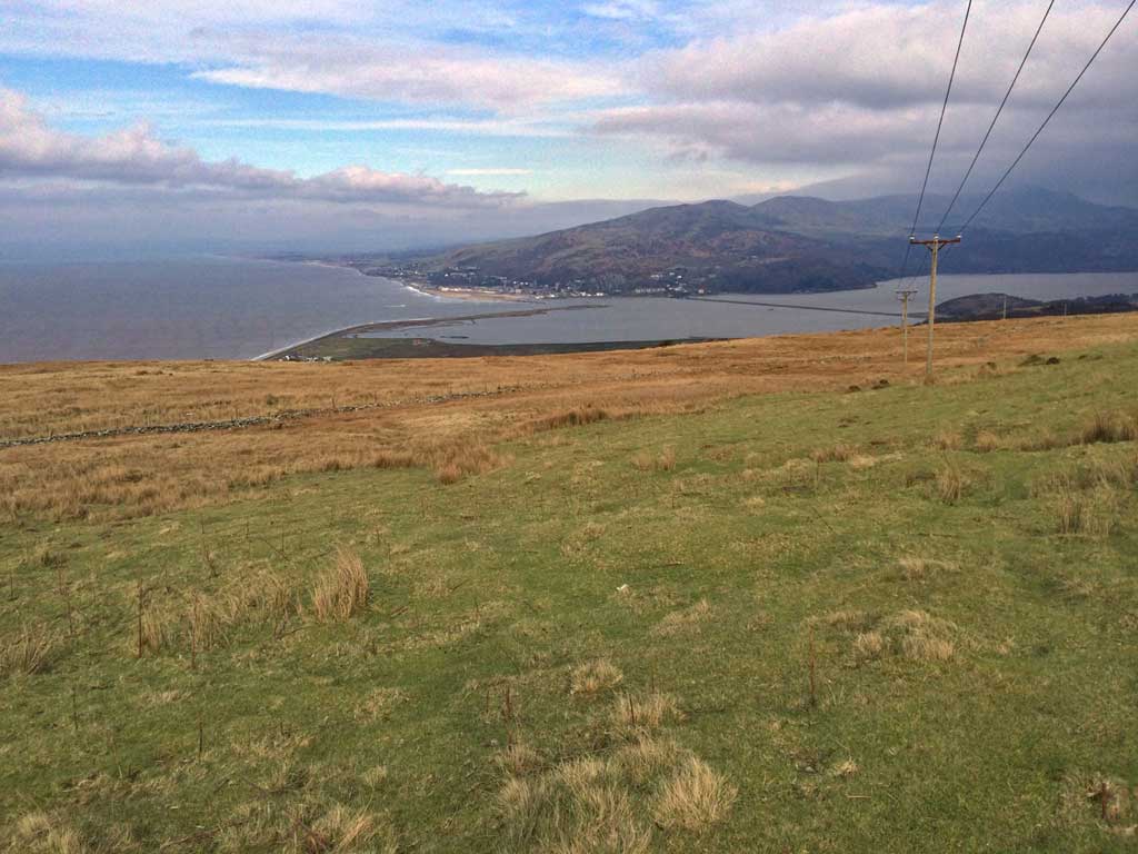
Mawddach Estuary
You can see see the long spit of land from Fairbourne, the southern edge of the Mawddach estuary that I would be running along soon, the Mawddach Bridge that I would be crossing on foot soon and then the coastline through Barmouth and beyond – my journey for the day. There was just time for selfie and panoramic photos before the road heads into coniferous forests where there was lots of felling work going on.
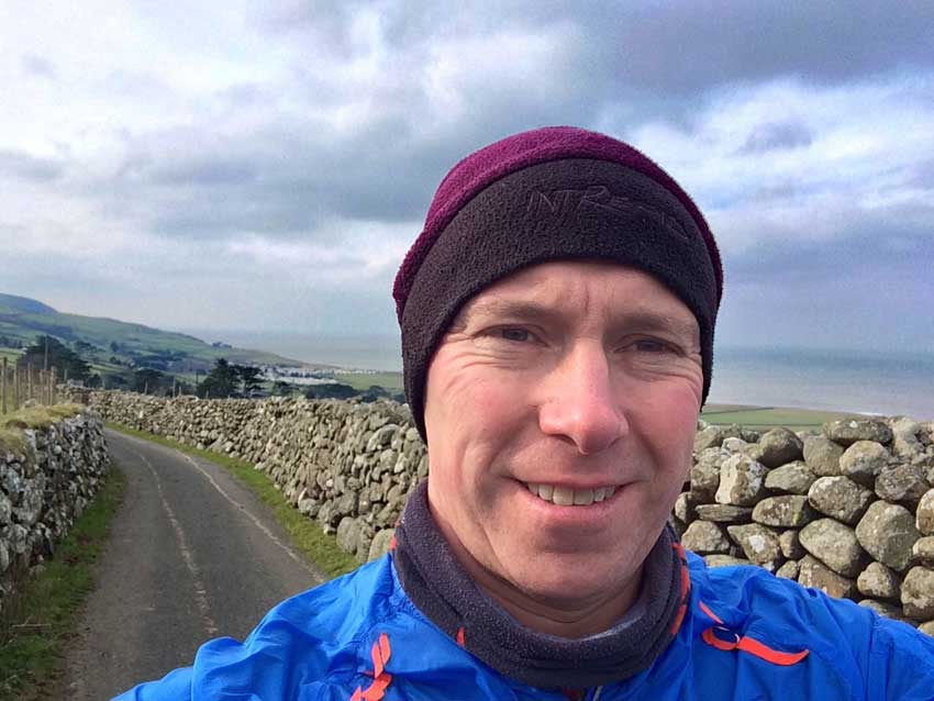
Coast Path Selfie Llwyngwril
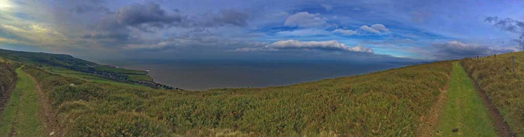
Wales Coast Path Panorama
The Coast Path then turns left off the road onto a track and then narrow paths which descend through fields, woodlands and old quarry workings. Although quite steep in places and therefore not particularly fast this descent was quite enjoyable as it weaved its way back and forth across the hillside and then emerged out onto the main road in Friog.
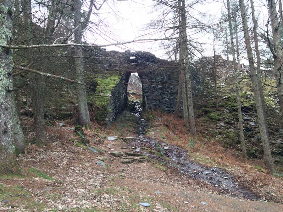
Quarry Workings
Back to the Coast
The Coast Path then doubles back on itself a little, heading south along the main road before you turn off right onto a smaller road under an impressive railway bridge constructed of huge stone blocks and then out onto the seafront at Fairbourne. Up onto and along the pebble strewn promenade along Fairbournes Beach. This is where the strong NE wind which became the major feature of the run really made itself felt. Along the exposed seafront it made progress difficult even though it was coming from the side.
Fairbourne was looking nice as the sun tried to break through, despite the fact that all the businesses, the amusements and the shops were all closed and boarded up for the winter. I ran along the prom and then crossed the narrow gauge railway and headed straight into the wind for a while as I ran around the southern edge of the Mawddach estuary seaward of the railway bridge. It was tough going along here thanks to the wind but eventually I made it to the railway line and some shelter for a while. This didn’t last long though as I was soon being battered by the wind as it howled down through the valley and hit me side on as I ran across the long railway bridge across the Mawddach Estuary towards Barmouth.
Barmouth Bridge also known as Barmouth Viaduct, is a single-track largely wooden railway viaduct that crosses the River Mawddach estuary. The bridge opened in 1867, and originally included a drawbridge section at its north end for tall ships to pass, though this was later replaced by the current swing bridge section. In 1980, woodworm threatened the safety of the bridge, which needed major repairs to avoid closure. Tolls were collected for foot and cycle traffic until 2013 and as of 2015 the future for non-rail traffic is uncertain. The bridge is one of the longest timber viaducts still in regular use in Britain.
Barmouth and Beyond
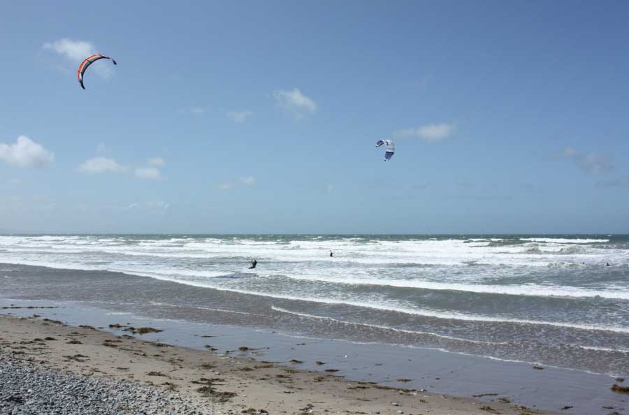
Once on the far side I ran through the busy streets of Barmouth and then out onto the main promenade. The prom and the road behind it were covered in sand so it was like running along the beach really. The beach itself had a few people on it and the small swell was breaking nicely with plumes of spray being blown off the tops by the strong offshore winds. Barmouth itself was quite busy as I passed amusement arcades, waltzers and fairground rides and the smell of fish and chips. It wasn’t beach weather though and everyone was wearing coats, hats and scarves rather than speedos and bikinis!
The Wales Coast Path goes all the way along the prom right to the far northern end where it turns right and crosses the railway line then heads up a short steep hill to the main A496. The coast path then follows this main road along the pavement for about 2½ miles. This seemed a shame as running along the edge of a main road isn’t that inspiring but it wasn’t busy today and it still afforded some nice views down to the railway line and the sea below.
Eventually there was a sign pointing down through a muddy field to the left. This was the first really muddy section today. Until now, all stages of the coast path had been big mudfests most of the way. Today had been relatively mud free, but the next mile through a few fields made up for the that. The fields were full of sheep munching away on sugar beet. There was virtually no grass in the fields, just ankle deep thick claggy mud that stuck to my shoes in great clumps and made them feel like big weights on the ends of my legs.
It didn’t last too long though and I soon emerged into a caravan site and a tarmac road that led me through the neat rows of static caravans to the sea beyond. A quick little dash across the pebbles and then I turned right onto a road through yet more caravan sites. I’d never stopped in Talybont before, just driven through it and didn’t realise just how many caravan sites and holiday homes there were here. The Coast Path didn’t actually come down the sea, so I’d overshot a little and ended up running an extra mile or so but I was now on the road that I had parked on so continued on to my car.
My legs were feeling it now and the 10 miles or so of almost flat running after the initial climbs had taken their toll. The planned 12 mile run had been a 14.5 mile run as well. I didn’t feel too bad though and with the sun now shining I sat on the tailgate of my car and got changed into clothes suitable for the drive home. I stopped off in Barmouth to get some scotch eggs and a milkshake, and bought some romantic Valentines weekend pressies for Anna while I was there. The drive home was OK with the northern slopes of Cadair Idris now visible below the clouds and looking impressive cloaked in snow.
That’s 5 stages down and I’m gradually making my way north. It takes longer each week thanks to the greater time involved travelling to and from my run, but I’m making good progress and having fun. The more I do of it, the more determined I’m becoming to actually do the whole circumference of Wales. Next week will be a run from Talybont to Harlech, but as my parents are here for the weekend I may have to see if they fancy a family day out in Harlech as part of it. The Castle should make for a nice day out and we’ve never visited it properly so plans are already afoot.
Discover more from A Simple Life of Luxury
Subscribe to get the latest posts sent to your email.


See the sun did shine for you x
Harlech sounds fine x