Wales Coast Path Run Machynlleth to Aberdovey
Coast Path Vital Stats
Machynlleth to Aberdovey
- Distance: 15.71 miles
- Elevation Gain Today: 664m
- Highest Elevation: 261m
- Time: 2:35:43
- Av. Pace: 10:20 mins/mile
- Av. Heart Rate: 140bpm
- Max Heart Rate: 171bpm
- Calories: 1489
Totals to Date
- Total Distance Completed: 48.62 miles
- Total Time: 8:42:45
- Total Elevation Gain: 2202m
- Total Calories: 5173
- Distance to go: 825 miles
Stage four of my Wales Coast Path run and today saw me going from Machynlleth to Aberdovey. Not only that but it saw several new records for me too.
- Longest run so far – It should have been about 11 miles but ended up at just over 15 miles
- Most times going the wrong way – I just couldn’t see the signs today and ended up going the wrong way at least 4 times, hence the extra mileage
- Deepest puddle so far – I thought that this category of records was sown up whilst crossing Borth Bog a couple of weeks ago where I spent half my time knee deep in water, but today I managed to find a puddle that went right to the top of both my thighs!
Wales Coast Path Run Preparations
The preparations for this weeks run weren’t ideal to say the least. After a busy day at work on Friday, we had to rush off to do some shopping ready for a Scout sleepover, and then head back to Borth and the Youth Hostel where the Scout sleepover was taking place. As Scout leaders we obviously had to be there and had to cook dinner for them all too. Once the Scouts arrived they were busy building airfix models whilst we slaved away in the kitchen. It was actually a very easy dinner to prepare as we had cheated a little by buying jars of bolognese sauce and pre-cut frozen veggies to make a nice quorn mince bolognese for them, along with chicken nugget based fajitas. That said, a sleepover with twenty 10-14 year olds is never a relaxing affair! In fact calling it a Scout Sleepover is a complete fallacy a more accurate term would be a Scout ‘Over’ as there is no sleeping involved at all. Certainly not for us anyway.
That was the case on Friday night, but for once not because the Scouts kept us awake by messing about. This time, there were all in bed by midnight and fairly quiet before 1am, but the wind was blowing outside and we were in a room under the roof so the tiles were rattling and the room was really noisy. Not a wink was had, and I mean not a single second of sleep, so by 4:30am I was getting a little fed up. I had planned to leave the Youth Hostel early anyway to pop home to do a turbo trainer session before returning. So, rather than lie there waiting until 6am I decided to head home at 4:30am and maybe, just maybe get an hour of snoozing in before my trainer ride.
That didn’t work either, by the time I’d got dressed, driven home, got undressed again and into bed, there was no way I was going to get to sleep. Then one of Morgan’s alarms went off at 5:15am anyway, and then again at 5:30am, followed by the light on Anna’s bedside lamp coming on at 5:45am, so I gave up trying, got out of bed and onto the turbo trainer. I’d now been awake for a very busy 24 hours, so had no idea how I’d perform on what was supposed to be a 90 minute Under-Over TrainerRoad interval session called Palisade.
The session actually consists of five 9 minute intervals which are each split into 3x 1 minute at 95% FTP and 2 minutes at 105% FTP. Quite a taxing intensity to be working at at the best of times and probably not ideal at 7:00am after no sleep. I battled through though and managed to nail every interval so finished it feeling fairly pleased with myself.
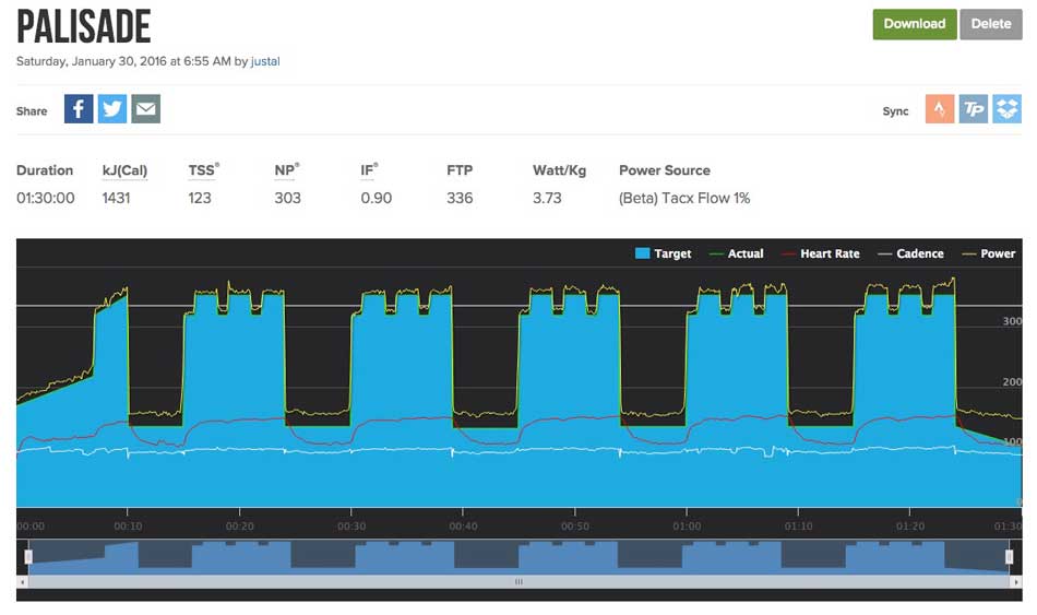
Palisade
It wasn’t easy, but I had done it and felt as though I’d probably be OK on my Coast Path run a little later as well.
Machynlleth to Aberdovey Coast Path Run
After a quick shower I headed back to the Youth Hostel to see the Scouts off and then Anna, Morgan and I headed off to Machynlleth. Last week’s Coast Path Run took me to the railway station in Machynlleth, so that was where today’s run had to start. Anna and Morgan dropped me off and away I went. They were going to drive into Aberdovey and meet me later. According the the Wales Coast Path Distance Tables it was 12 miles to Aberdovey. I knew various parts of the route which meant I knew there would be a lot of climbing so told Anna that I would be somewhere between 2 and 2 ½ hours.
Border Crossings
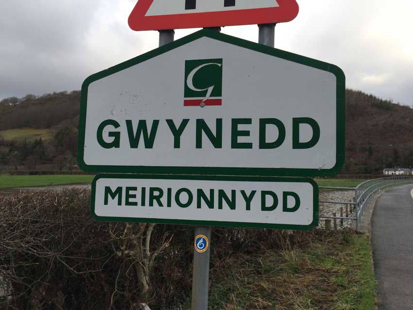
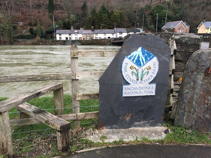
It all started well as I eased into a nice steady pace out of Machynlleth and towards the River Dyfi. I was crossing a border here, out of Ceredigion and into Gwynedd. The first border crossing of my Coast Path run so far as I continued my way north. I was also entering into the Snowdonia National Park and crossing the River Dyfi.
-

- Into Gwynedd
-
- Snowdonia National Park
The River Dyfi had been the cause of the fairly long detour inland so after crossing it’s swollen waters I took a left hand turn and started heading west, back towards the coast.
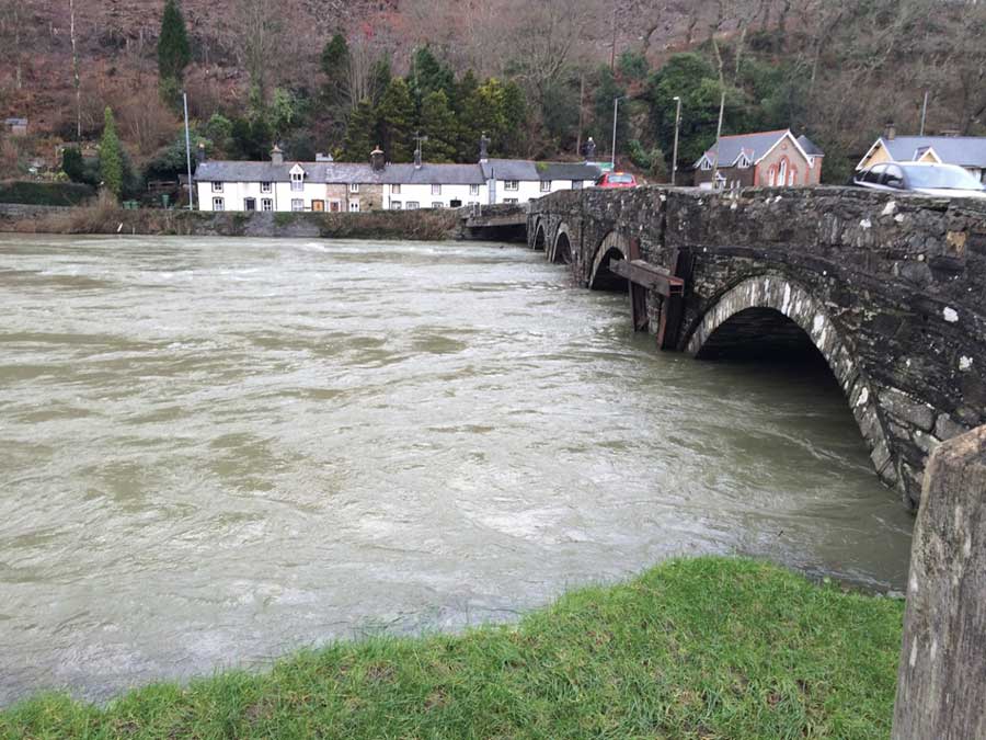
Swollen River Dyfi
I was still quite a long way from the coast though and there were a few fairly substantial hills between me and Cardigan Bay, the first of which started immediately as I made my way up the long steep climb of Bron yr Aur. This climb seems to go on forever with a number of false summits. It did however provide some lovely views of the flooded Dyfi valley stretched out below. At one point I went past a footpath sign that looked as though it could be the way I should go, but it didn’t have a Wales Coast Path emblem or sign on it so I made sure I didn’t make the same mistake as last week. I ignored this footpath and continued on up to the very top of the hill feeling confident that I’d made the right choice to wait for an official Wales Coast Path Sign. After half a mile though there was still no sign and things were looking wrong. I decided to get my phone out and check out the Wales Coast Path App – sure enough I was quite a long way off track and should have taken the anonymous footpath sign earlier. I retraced my steps back down the hill, took the footpath and once again climbed another equally steep hill up into the forests above Pennal. As I pfaffed about looking at my phone though my GPS stopped as I wasn’t moving and I didn’t notice until later that it hadn’t restarted when I started moving again. If you look at the GPS trace you’ll see that it missed out about 0.5 miles of my run so I’ve added that on to the stats as an error correction.
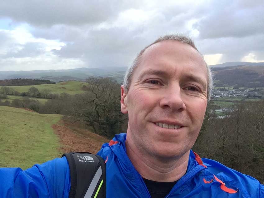
Smiley Selfie
I was now on familiar ground again as I made my way down some steep narrow and very muddy trails, onto the forest roads and eventually the long descent into Pennal. I knew that the path crossed the main road here and headed out towards the River Dyfi a little bit. I crossed the bridge in Pennal by which time I was just over 5 miles into my run, was making good time and was feeling good. Still a long way to go but at this rate I’d easily make it in under 2 hours despite my earlier detour – that is if I stayed on track from here….
I then saw a footpath sign that headed off in about the right place towards the River Dyfi. Once again it didn’t have a Wales Coast Path emblem on it, but after the earlier mis-routing I followed it. I did try to take a look at the Coast Path App again to check I was on track, but as I did so, the battery in my phone died. I now had no map to follow, no means of taking photos and no way to make a phone call should I need to do so.
A mile or so later, after some pretty boggy running and without seeing another footpath sign anywhere the path petered out on the marshy banks of the river. Another wrong route and nothing to do but turn around and head back. Halfway back towards the road I saw a footpath sign pointing off in the right direction towards the holiday homes of Plas Talgarth. I followed it, this time across a muddy field and then into some really boggy marshy ground alongside a stream that led towards a bridge that crossed the stream towards Plas Talgarth – where I knew I should be. It looked as though it was going the right way but the bridge led nowhere, on the far side there was just water, mud and barbed wire fences. Another dead-end, another mile or so of unnecessary running and time once again to retrace my steps through the mud and marsh, this time all the way back to the main road!
I had started saying to myself that if I’d lost the path I’d just have to follow the main road and pick it up again where I knew it crsosed the road later just beyond Cwrt. However, once back at the main road, I discovered an official Wales Coast Path sign, about 50 yards further along the road, this time pointing directly towards Plas Talgarth and along a nice flat, tarmacked road. This was quite a treat after the mud and mire I’d just been through, if only I’d found it straight way, I would have saved myself about 2.5 miles and half an hour of running and a whole lot of mud too.
The road soon turned upwards though, up through the holiday homes of Plas Talgarth and then out into some woods, before weaving its way across fields, through gates, along some tracks, through a courtyard and finally after a bit more road and another sodden field, and finally across the main road once again.
Once more into the Hills
Once again, the road headed upwards, yet more very steep terrain and a whole lot of climbing, first on tarmacked road and then out onto what looked like an ancient Roman Road of rocky terrain. I’d now covered around 9 miles in total (including the extras from my earlier detours) and was at what should have been the halfway point. By my calculations that would mean that the run would end up being somewhere around 15 miles rather than the planned 12 miles, so I still had about 6 miles to go. From here at just above sea level, the route climbed constantly to about 850 feet above sea level and the headwind grew stronger and stronger as I went. It was nice up here though as I passed the occasional rambler, including a couple that I knew from our beekeeping association. Out onto the top and I started to get some tantalising glimpses of the sea. I was at last approaching the coast again and what had become quite a hilly section of the route would once again become more coastal. The views down into Happy Valley were amazing, I just wish that I had a camera to take some photos, but I didn’t so you’ll just have to make the effort to get there to see them for yourself.
Mud, Wind, Puddles and Panoramas.
As I continued along the muddy and rocky tracks across the tops of the hills, there were some pretty big puddles. Walkers had made little paths through the rushes to the sides of these which led to lots of wading through the boggy, rushes to the sides of the bigger puddles. Whilst negotiating one of the wetter boggy rush patches I managed to find myself in the deepest ‘puddle’ of my Wales Coast Path Adventure so far. Both legs disappeared as I felt myself sink deep into it. The icy water went right up to the tops of my thighs soaking me through as I managed to throw myself forwards, grab hold of some vegetation in front of me and haul myself back out. I was drenched, everything from pretty much my waist down was soaked and soon started to get very cold. As I splodged onwards I could feel the water draining into my already squelching shoes and my legs were beginning to seize up a little with the cold. There was nothing to do but to keep going in an effort to warm back up, but the wetness soon started to make itself felt as it started to result in some chaffing to some of my more delicate areas! The cold biting headwind didn’t help but I was still making progress and with around 12 miles now under my belt it couldn’t be much further – could it?
There were a few more slightly unexpected climbs, and some absolutely amazing views out across the Dyfi Estuary to Ynyslas, our house and Borth beyond that. Once again, with no camera I’m unable to share them with you, but even with all the wrong turns, extras miles, deep, deep puddles and uncomfortable nether region chaffing it was worth it for the views. Eventually the path took a left hand turn and started heading down hill on a fairly decent path. At least it did for a short while and then a sign pointed out across a very wet, muddy, cattle-trod field. I duly followed the sign and gingerly picked my way across the torn up field not really sure exactly where I was heading. From there I couldn’t see another sign and there were no obvious landmarks in the form paths to follow, gates to aim for or anything else so after running around the field for a while I finally spotted an exit quite a way below me. I made my way down the steep bank and emerged onto a small concrete track. There were no Coast Path signs here though and I could see no other way to go, so as time was now getting on a bit I decided that the best option was to simply follow the track downhill – it could only emerge either into Aberdovey itself or onto the main road just outside or Aberdovey and once there I would know where I was.
Into Aberdovey
Sure enough, the track soon turned into a small road, there were houses here and there and then it emerged into Aberdovey right by the railway bridge. I wasn’t quite on the Coast Path but I wasn’t far from it as I started making my way along the road towards the Yacht Club car park where I was to meet Anna and Morgan. About 100 yards along the road I spotted where the Coast Path did actually emerge onto the road, but quite how you got into this path from the top I still don’t know. I continued along the road into Aberdovey wondering why there was no one out windsurfing or kitesurfing in what were absolutely perfect high tide Aberdovey conditions. Eventually, 2 hours 37 minutes after starting and 15.7 miles later I met Anna and Morgan in the car park.
Strangely enough, this car park is probably the closest point on the official Wales Coast path to our house. As the crow flies it’s about 1.5 miles away from our house, however, it had taken me about 30 miles of running to get here and the journey home in the car would take about 50 minutes!
I had told Anna that I’d be there sometime between 12 and 12:30 and it was 12:27 when I got there – If it weren’t for the extra 4 or 5 miles of detour I had made then I would have been quite early, but as it was we had no time to waste, I had a quick change and we headed home for a shower as we had to be back in Aberystwyth for 2:30pm.
I was now back on the coast after the long journey inland to cross the River Dyfi. Stage 4 of my Wales Coast Path run adventure was over and things were going well. I have a bit if a dilemma as to whether or not to include the detours in my data but seeing as I’ve done them I think I will. I’ll have to make adjustments to my calculations of the number of miles to go though. The various sections of the Coast Path between Borth and Aberdovey aren’t very coastal, but as I said last week, they are still enjoyable. Today’s run, especially the bits up above Happy Valley and looking down across the Dyfi Estuary were indeed spectacular and although the sea may seem a long way off they are still very worthwhile doing. Next up will be a long slog along the sands between Aberdovey and Tywyn so no doubt I’ll be longing for the hills as the sandy beaches sap the energy from my legs. It’s all part of the adventure, so on it goes.
Discover more from A Simple Life of Luxury
Subscribe to get the latest posts sent to your email.


I always thought that in was gloucester that had the deepest puddle…when Dr Foster stepped in it right up to his middle.
How are you going to get to and from the further routes? As I have the feeling that you will want to do the whole route. X
SHould be OK up to Pwllheli as the Cambrian Coast railway runs all the way up the coast to there so I can drive to the start point, run as far as I like and then get the train back to the car – beyond that, we’ll just have to have some days away I think.
Al.
I’m not surprised you already had a plan of action in place! X