Not Camping in The Cambrian Mountains
With the weather looking good I decided to head off for a hike and wild camp on Sunday. The plan was to bag a few summits that I hadn’t been to before, find a nice little camp spot miles from anywhere and camp out for the night. I’d then walk up a couple of other hills on Monday morning and head back to the car and home.
I was up quite early on Sunday morning and watched the Grand Prix qualifying on catch-up. Most of my camping kit is kind of ready to go so packing was pretty quick so I decided to head off around 9am. A little earlier than expected but that’s always the way with me.
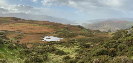
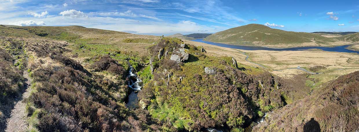
After a bit of a drive I parked up at Nant y Moch around 10am and set off under blue skies. There was a light breeze so the air was cool but I soon warmed up as I made my way steeply uphill towards Pumlumon. I stopped now and then to take in the views of Nant y Moch reservoir below me.
As is often the case on these little trips I had new kit to try out – today it was a new pair of Altra Lone Peak trail shoes. They were soon soaking wet as I squelched through boggy bits of ground but they felt good.
Pumlumon Summits
The first summit of the day was Pumlumon Fach (664 m), a subsidiary summit of Pumlumon Fawr.
From here I descended down through a little valley to Llyn Llygad-Rheidol nestled in it’s impressive amphitheatre.
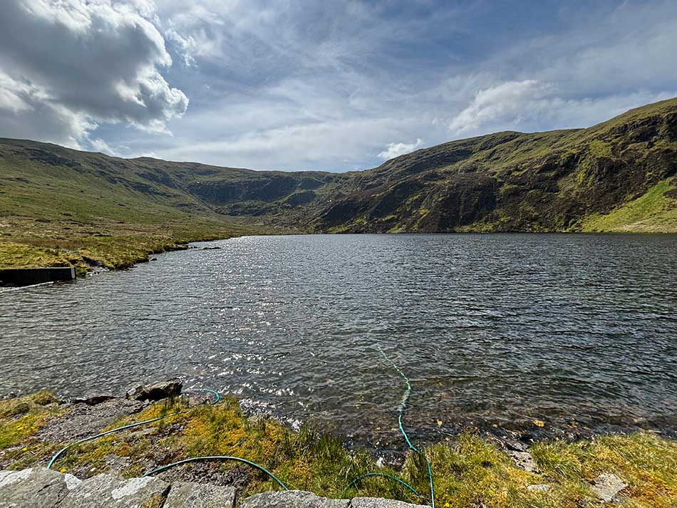
This lake is the source of the River Rheidol. Despite the sunshine the stiff breeze made it quite chilly along it’s shores. That would soon change though as I started a strenuous climb towards the next summit of Pen Cerrig Tewion (680 m).
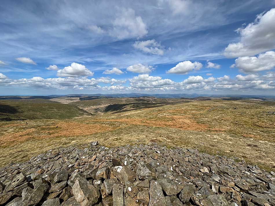
I was now up on top of the Cambrian Mountains and into the typical rugged, remote wilderness that it is known for. There were no paths, no real landmarks and just endless acres of tussocky grass and bog. The summits are often difficult to discern around here as well due to the fairly flat topped nature of the hills. I wandered around to a few of the likely looking suspects here and then headed off towards summit number three at Pen Pumlumon Llygad-bychan (724 m).
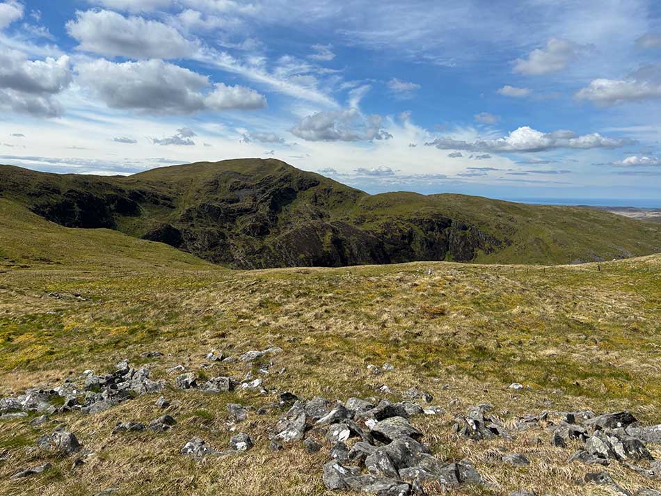
From here I descended slightly and joined a path not far from the course of the River Wye. I was able to follow the path on easy going ground to the highest point of the day, the summit of Pen Pumlumon Arwystli (741 m). At just 11 m shorter than its big brother Pumlumon it’s about as high as you can get in the Cambrian Mountains. I took shelter in one of the stone circles and sat down for a while to eat my lunch.
Towards Glaslyn
After lunch I continued along the path heading basically north towards the area I was at last weekend. There was no one around and despite the easy path it felt quite remote out here. I was however heading towards the source of the River Severn and paths that are more frequented so as I approached I did see a few people here and there.
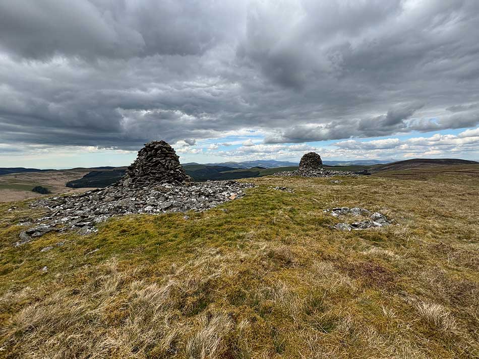
I left the paths behind though and once again struck out across country to bag the indistinct peak of Carnfachbugeilyn (622 m). Once again it was difficult to tell which exact part of the peat bog was the summit. The next summit, Pumlumon Cwmbiga (620 m) was much easier to find with its two huge stone cairns.
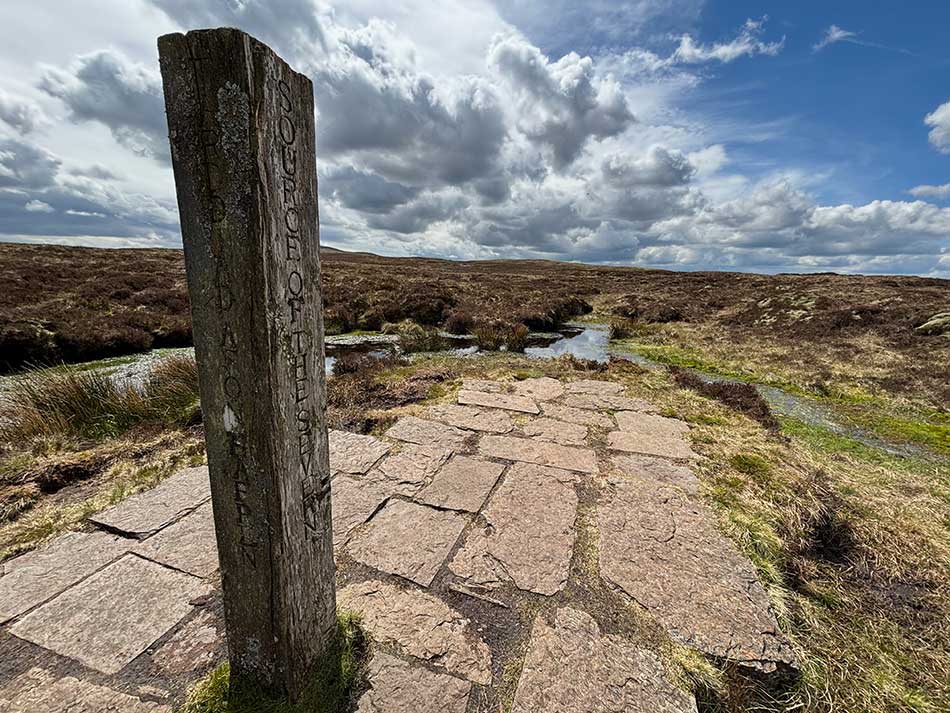
Source of the Severn
I now had a tricky traverse of a peat bog in order to find the path that led to the source of the Severn. Once on the stone path the going easier and I headed past the source of the Severn and pack up the hill to cross my path that I’d taken earlier.
There was a little pile of quartz rocks on top of a summit here, but I don’t think it was a listed summit. I visited it anyway and then wandered across the top of a little ridge leaving the paths behind me once again.
Cwm Hengwm
Next I dropped steeply down into the Hengwm Valley where the River Hengwm could be seen meandering its way through the grassy bog at the valley floor.
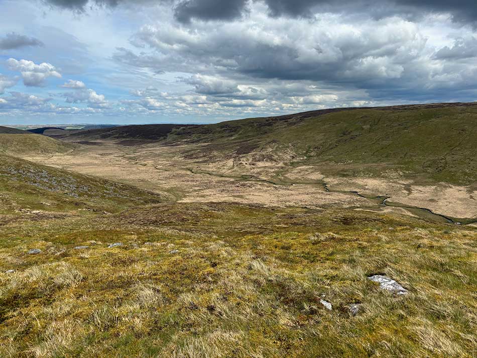
I could see a path on the far side of the valley that I wanted to get to. It was a long descent that wasn’t kind to my knees and I could see no way across to the path without something of a slog through the boggy valley.
I set my sights on a landmark on the far side and set off into the tussocky grass prepared to get wet. The boglands of Mid Wales didn’t disappoint. I was soon on dodgy ground, sometimes disappearing thigh deep into the grassy bog. The going was tough but I was making ground and soon crossed the river. There was no real ‘river crossing’ but things just got a lot wetter for a while as I sploshed through the bog. There were a few obvious streams but really it was just a big marshy sponge! Some steps would be fine and the tussock of grass that I chose would indeed be solid ground, most weren’t and I’d disappear into a hole hoping that I wouldn’t end up swimming!
Once across the main bog I started to gain a little height on the other side of the valley and eventually emerged at the end of a track. Here there was at least some solid ground so I turned left and head along the base of Llechwedd Crin, a hill I had summited last week.
A few more summits
I made another stream crossing, and filled my small bottle up with water as I did so. I then once again left all traces of paths behind me and started a steep climb towards the summit of Foel Isaf (548 m). This climb was through bog at first and then thick heather. I wandered across the top hoping to hit the summit and then picked a route down its western flanks.
I was now starting to look for somewhere to camp. The requirements were a flat, relatively dry bit of ground, preferably with some shelter from the wind and a nearby water source. I passed some old walls that were either the remains of a dwelling or some sheep folds. There were a couple of likely-looking spots here but the ground was quite boggy so I continued on. The climb to Foel Uchaf (565 m) was once again through tough vegetation and on steep ground. There was nowhere flat to camp here. There was however a few nice spots just below the summit on the NW side. Unfortunately, there was no water source nearby and I didn’t fancy a descent all the way down into the valley and back up so that I could collect water.
From the top of Foel Uchaf I could see across to the twin cairns of Carn Hyddgen the next summit on my list. The direct route into the valley and back up looked very wet and boggy so I took a slightly longer route through undulating peat bog until I found a semblance of a track and then followed that around to Carn Hyddgen. Again, there was nowhere to camp along here. I reached the cairns at Carn Hyddgen (566 m) and scouted the land before me for likely camp site.
I saw a few not far from the steam of Nant y Garn but when I got to them they were either very wet, not as flat as they looked from above or were very tussocky. In hindsight, having looked at the aerial images maybe if I’d climbed a little further back up the valley along the course of the stream I may have found somewhere suitable there, but I’m not sure.
Almost Home
I therefore soon found myself on the track alongside the Afon Hyddgen. I followed this, looking for and investigating a few possible campsite but coudn’t really find anything suitable. I was now also less than 2 miles from the car so was beginning to wonder if it made more sense to just complete the walk and drive home.
I crossed the river on a little footbridge, still looking for campsites and investigated some of the areas around the old settlements here. I forded the stream of Nant y Llyn too. Last time I was here it was impassable. I then set off along the track towards the car with the odd detour to find a campsite. I was still in two minds about camping out or heading home. If I found a perfect spot I’d set my tent up, if not it would be home for a proper meal and a proper bed.
I was soon back at the car and heading home. I did stop off at one point and wandered down to the shores of Nant y Moch in search of the perfect campsite, but it was a lot muddier here than it looked from the road, so after that, I decided enough was enough and it made more sense to head home.
What was supposed to be two shortish days in the hills with an overnight camp between them ended up being quite a long day in the hills. It was less than 15 miles in total, but the difficult terrain in these parts made it feel a lot longer.
I guess next time I need to either start looking for a campsite earlier in the day or be a little less discerning about where I camp.
Discover more from A Simple Life of Luxury
Subscribe to get the latest posts sent to your email.