Cadair Idris and Foel Ispri Geocaching
Morgan is still quite enthusiastic about his geocaching. He’s keen to go out in the morning to find a new geocache and is motivated by the thought of breaking records. Our consecutive days geocaching streak is now up to 17 and he wants to keep going. Of course, each day gets more difficult as we begin to exhaust the local caches and have to start moving further afield to find new caches. He also has a new challenge – to complete a 5/5 geocache.
Geocache Ratings
All geocaches are rated on a scale of 1-5 for difficulty and terrain. A rating of 1 for terrain is a fully accessible geocache where the “terrain is likely to be paved, is relatively flat, and less than a ½ mile hike is required.”. Terrain rating 5 “requires specialized equipment (boat, 4WD, rock climbing, SCUBA, etc.) or is otherwise extremely difficult.” Difficulty ratings can be based on a number of things such as the way the cache itself is hidden or the fact that the co0ordinates can only be worked out after solving a cryptic puzzle. A difficulty rating of 1 applies to a geocache that is “in plain sight or can be found in a few minutes of searching.” A difficulty rating of 5 only applies to geocaches that are a “a serious mental or physical challenge and may require specialized knowledge or skills to find or open the geocache.”
Geocache Ratings
A 5/5 geocache should therefore be both a serious mental or physical challenge requiring specialized knowledge or skills to find and require specialized equipment (boat, 4WD, rock climbing, SCUBA, etc.) or by otherwise extremely difficult!
Bagging a 5/5 Geocache
Anna and I did a 5/5 cache many years ago when Morgan was quite young. The cache was called Wildcat and did indeed take us several days to complete. We started work on it back in November 2006. We then spent some time verifying the coordinates we had found and eventually found the cache itself on December 18th 2006. It wasn’t actually as difficult as we thought it might be, but it did take some time thanks to the fact that we had to do quite a bit of research online to solve various cryptic clues. We then had to visit various locations around the Cotswolds to answer yet more cryptic clues and finally we needed some specialist equipment in the form of a kayak to retrieve the fairly well hidden cache. Morgan was too young to remember this though so now wants to do a 5/5 geocache of his own.
We looked them up and found one in North Wales called Gwyddno’s Mountain Challenge that sounded like a suitable candidate. In order to find the final cache you have to first find 5 of his other caches:
- Penrhyngwyn – Rock Cannon 4 (GC187H7 )
- Moel yr Hydd – South Snowdonia (GC1312V )
- The Big Wheel – Dinas Mawddwy (GC10Z0K )
- Foel Ispri – South Snowdonia (GCYKP4 )
- Llaeron Earth Is It? (GCXYZ4 )
Each of the above caches has at least 2 of his photos of mountains in it, with a question about each picture. Using the first letter of the answer to each question will give us a number that can be used to find the coordinates of the final cache. As you can imagine, the five caches above are all on fairly significant hills in North Wales and therefore require a considerable amount of hill-walking. Some, if not most of them are off the main paths too so require some navigational skills and no doubt the final cache itself is the same, if not harder. The questions we have to answer are a mixed bunch too. Having seen a few of them now, I immediately knew the answers to some of them, but others required a bit of Internet research.
I’d already done a couple of the caches listed, but yesterday Morgan and I set off into the hills to find “Penrhyngwyn – Rock Cannon 4” on Cadair Idris and possibly “Foel Ispri” as well.
Preparing for the Hills
While Anna got ready to go to work, Morgan and I prepared for the hills. Suitable clothing was donned and extra clothing packed into my rucksack, along with waterproofs, first aid kits, compass, maps, plenty of snacks and of course a drink, GPS device, torch and mobile phone. We packed the car and headed off at around 9am.
Our first mission was to find some vimto bonbons, or ‘geocaching berries’ as Morgan likes to call them. We stopped at couple of shops on the way but were unsuccessful in this first quest so had to make do with chocolate as a reward for finding a cache instead. We then drove through Dolgellau and on to the car park at the foot of the Pony Path. Here we had to scrabble around to find some coins to put in the pay and display machine. It was £2.50 for the day, but I could only find 17p so once again we were unsuccessful with this too. I had a £10 note but no change and no-one else around had any either. The occupants of the next two cars to arrive had the same issue as well, so in the end we simply couldn’t pay for parking.
We put on our boots and grabbed our walking poles and got ready to head into the hills. There was however a geocache in the car park here, aptly called ‘Cadair Idris Car Park” so we found that one quickly before setting off – success at last and the first cache of the day which obviously called for some chocolate.
The Pony Path.
Our chosen route for the day started with the Pony Path. This is the easiest, but longest route up Cadair Idris. From the car park this path follows a track up to TÅ· Nant farmhouse where we cross a concrete bridge over a stream and pass through a mixed woodland of birch, hazel, sycamore, ash and hawthorn. We stopped for a while here so that Morgan could put his waterproof coat on as it was drizzling a little and we watched a wren flitting through the undergrowth.
Once out of the woodland, the path becomes rocky and climbs very gently with a number of water bars to help prevent erosion. Soon we came to what used to be three large sweet chestnut trees where we turn right following the marker posts. Some of these large trees seem to have been felled recently, possibly during winter storms. We then passed through the kissing gate and crossed the stream over a stone bridge. Here the slope starts to increase as the path heads out into more open terrain. The path is well maintained and involves some large stone steps for a while. We then passed through a gap in dry stone wall and on more open hillside. We were catching another couple up in front of us, but Morgan was warming up now, so we stopped for a drink and to allow Morgan to take his coat off. We soon continued on squeezing between a pair of hawthorns. The only trees around are dwarfed and twisted hawthorns as we worked our way higher onto the hill with some amazing views of the valley below and a glimpse of the Cregennan Lakes to the West and the sea beyond. We kept to the steps built into the slope and then passed through a gate and over a small bridge.
This was as far as we were going on the Pony Path, so we stopped as I pointed out some features of Cadair Idris to Morgan. I showed him the general route of the Pony Path as it made it’s way to the summit. I showed him the impressive cliffs of Cyfrwy off to our left and the route of the Cyfwry Arete climb. I even showed him the ledge I stopped on for lunch when I climbed it. Unfortunately though the summit of Cadair Idris was shrouded in mist and murk so I could only show him where it should be.
Off to the Cache.
Our route took us left here, following close to a high dry stone wall. There are a couple of poorly defined paths along here, one that leads off to the base of Cyfrwy Arete and around Llyn y Gadair, and a small sheep track that follows close to the wall. We followed the latter as it headed in the general direction of the cache. We were soon crossing marshy ground and having to negotiate small streams and a few larger stream crossing. This part of Cadair Idris is riddled with such streams, all running down to become the Gwynant River.
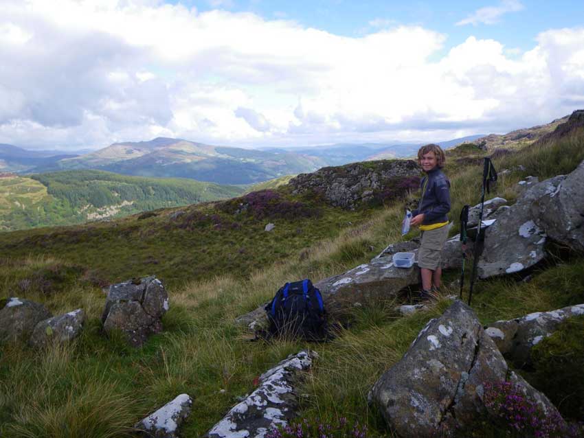
We managed to keep our feet fairly dry though and were soon within striking distance of the geocache. From our little sheep track it was just a short hike across the hill through the heather to the cache location whereupon we found the container without any issues at all. We stopped to sign the logbook, take in the views and have some snacks. We also took a photo of the questions for the Mountain Challenge cache and wrote them down too just in case.
-

- Cache Found
-
- Morgan with Cyfrwy Arete in the background
Suitably nourished and with the main cache of the day completed, it was decision time. Continue up to the summit, head off to Foel Ispri and another geocache or into Dolgellau for hot chocolate and cakes. The latter was decided upon!
Lunch time.
Rather than follow a path back to the car we descended through a steep field weaving between boggy patches and stunted hawthorn trees down towards a track that took us to Ty Nant farmhouse and back to the car. We jumped in the car, let Anna know that we were off the hill and headed off to one of my favourite cafes, y Sospan in Dolgellau. Morgan was talking about having a chilled afternoon and heading home, but once he’d eaten some scampi and chips and had a hot chocolate with marshmallows and cream he was keen to get back out into the hills and surprised me by suggesting that we do the Foel Ispri cache as well.
I didn’t take much persuading so after a relaxed lunch we headed up the road to Llanelltyd where we prepared for hill walk number two.
Foel Ispri
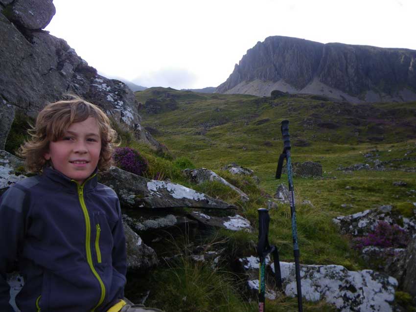
I’d never been up this particular hill so didn’t know the best route to take. We consulted the map, made some plans and set off up the steep slope following the footpath along the edge of the woodland out of the village. It was quite steep here but eased off as we emerged from the trees. This particular geocache was a multi-cache, so we didn’t have the coordinates of it yet and had no idea where it would be. The cache description said: “Finding the multi cache will take you on a route that will probably take most folks most of the day. It takes me about 4-5 hours with a group of 10 year olds”. I was hoping it would take a little less time than that, even with a 9 year old, as it was already 1pm.
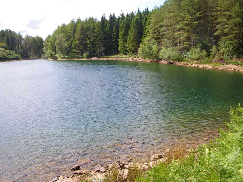
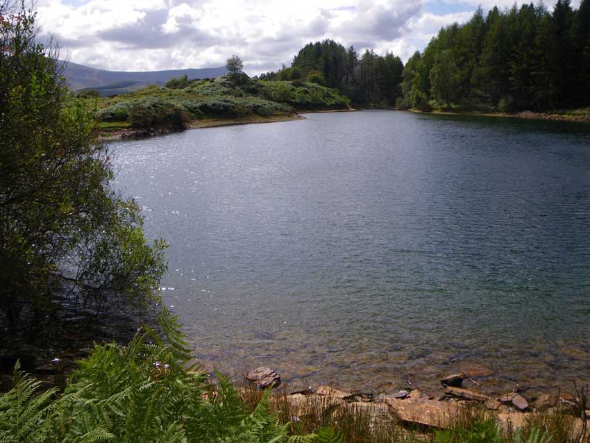
The first location was at the far end of the small Llyn Tan y Graig reservoir. We crested the small hill before it from where we had some nice views of Cadair Idris (now bathed in sunshine). We could just about see glimpses of the lake but the path we were on seemed to have disappeared and our way was blocked by a fence and head high bracken. We followed the edge of the bracken and soon found a small path through it and out onto the lakeside. With the sun shining and no one around it looked like a lovely spot for some wild swimming, but we had no time for that. We had a geocache to find.
-
- Cadair Idris
-
- Lakeside
-
- Perfect Swimming Spot
We soon found the container and collected the clue for the next stage. I won’t tell you what it is, but needless to say it involved a walk to the summit of Foel Ispri. We consulted the map again and planned a route along the myriad of trails that weave their way across this hill and set off on our way through the coniferous wood. Somehow we missed the trail on our right that we were looking for and ended up crossing a bridge over a stream that tumbled its way down the steep hillside. We continued on this way for a little while before I decided that we were heading off course. We doubled back a little and then followed a poorly defined track up the hillside through the woods. The trail soon disappeared though but we could see the edge of the woodland at the top of the hill. The map showed the track that we wanted to be on just beyond this, so we decided to scramble up the hillside towards it.
It was quite a scramble at times, very steep and over slippery moss covered rocks and loose forest ground. We ended up back by the stream we had crossed and stopped to catch our breaths and look at baby frogs and other beasties every now and then. We finally reached the edge of the woodland where we came upon a fence that we had to climb over. That was the easy part though as our way to the track was now blocked by 50m of dense, head high bracken. The only option we had was to ‘bush-whack’ our way through it. It was head-high for me so way over Morgan’s head and even though I was only a few feet in front of him he soon lost sight of me. In the end he stuck his walking pole in the air so that I could see where he was!
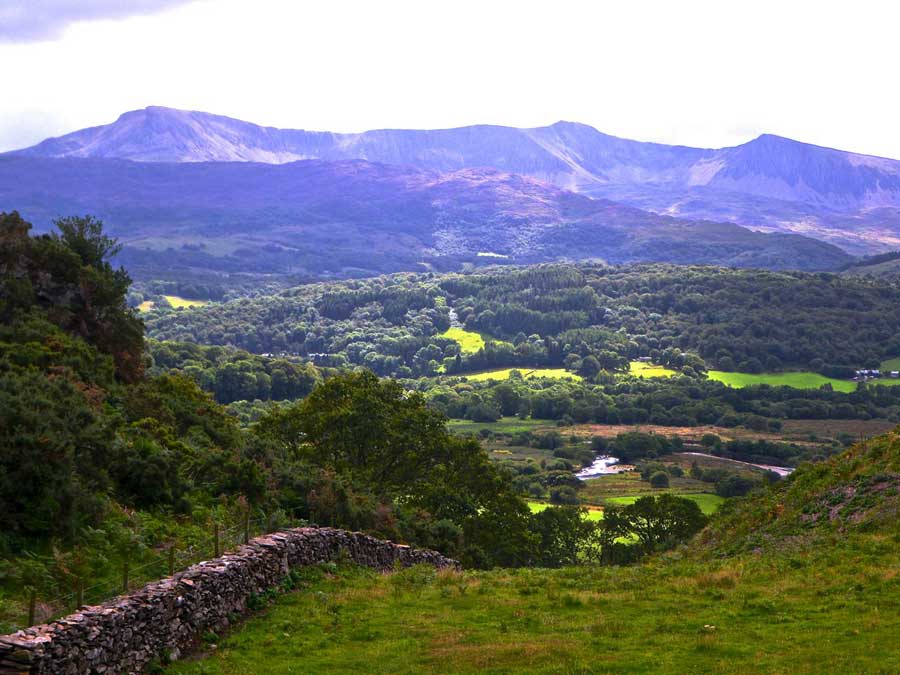
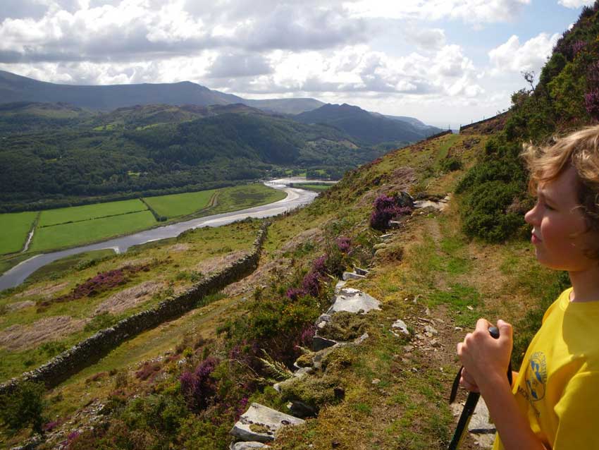
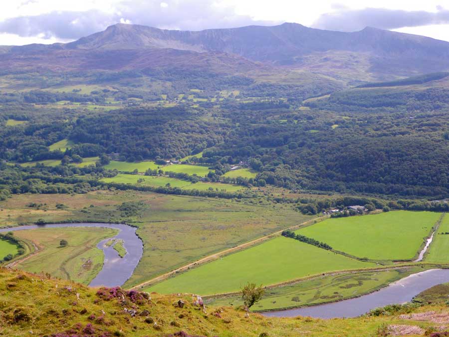
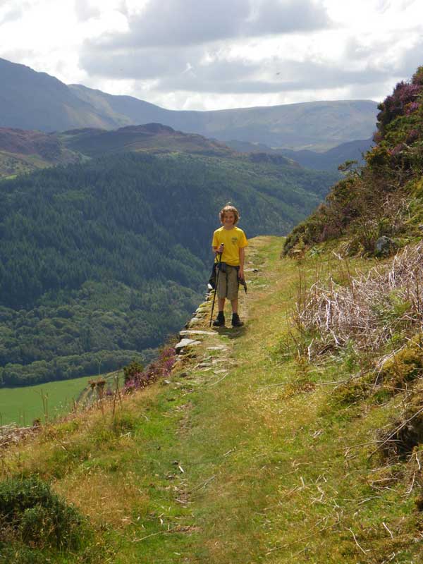
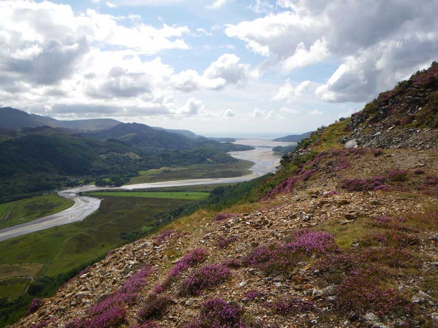
We made it out in the end though and onto the trail we had been searching for. We emerged by a derelict farm building and I commented on the fact that this would have been a a good location for a geocache. We had a drink and then continued along the trail towards the summit. This section of the trail is known as the ‘New Precipice Walk’ as it hugs the contours way above the valley below. The views from here were amazing, with the peaks of Cadair Idris to the south towering over the landscape, the river Mawddach meandering it’s way through the valley, under the bridge at Penmaenpool and opening out into the Mawddach estuary at Barmouth in the distance.
-
- Admiring the views
-
- Cadair and the Mawddach River
-
- Mines
-
- Precipice Walk
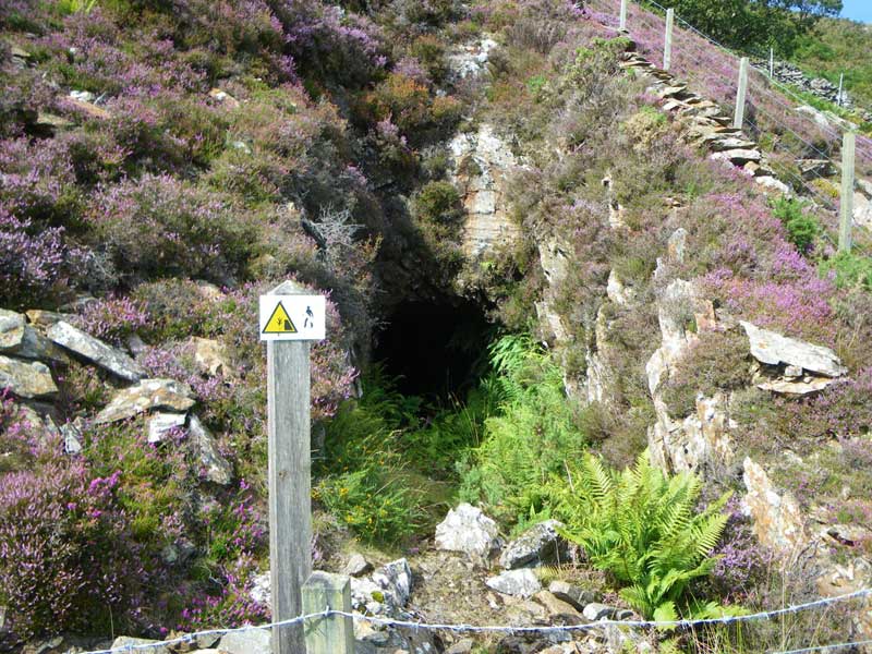
The hills here are riddled with old mine workings so we passed plenty of fenced off mine-shafts and mines heading off into the darkness of the underworld. We however were now roasting in the sunshine, surrounded by the purples and pinks of heather and kept company by butterflies and honey bees feasting on the nectar. There must be some bee-hives nearby as the heather was covered with bees in places.
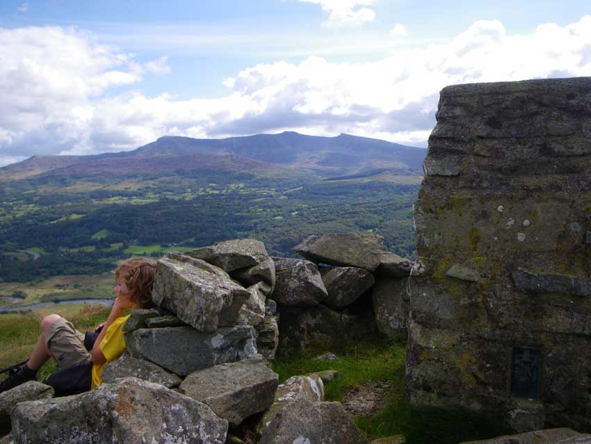
We made our way to the summit where we were able to find the final pieces of the clue and work out the coordinates of the final cache.
-
- Mawddach
-
- Relaxing at the Trig Point
It was only 0.16 miles from here so after a quick rest we headed off to find it. I won’t say where it is as I don’t want to give too much away, but it wasn’t far from the derelict farmhouse that I said would have made a good spot for a geocache! We soon had the cache in hand and had found the second of our Mountain Challenge caches of the day. We signed the logbook, admired the views once again and set off on our way.
This time we had no problem in following the path that we should have been on through the forest. Somewhere it must have crossed the path that we had taken earlier in the day, but despite looking out for it to see where we had gone wrong we didn’t see it. It just goes to show that once in amongst the trees and heading in one direction, it can be difficult to see paths crossing your trail, which may explain why we had missed the trail we were now on earlier in the day.
We were soon back at the lake and then heading down towards the the deciduous woodland towards Llanelltyd and the car. It was here that we realised we had forgotten to take note of the clues for the Mountain Challenge when we had found the cache up on Foel Ispri. We did contemplate going back to get them as it wouldn’t take long now that we knew the trail, but in the end decided that a quick email to the cache owner explaining that we had been idiots would probably be sufficient for him to give us the clues.
We arrived back at the car after a thoroughly enjoyable two and a half hours in the hills. Luckily it hadn’t taken too long so we managed to get home just before Anna arrived home from work.
That was three geocaches in total, another day added to our consecutive days record and more importantly two of the caches towards our 5/5 geocache challenge. We are now running out of time during these school holidays though and with summer on it’s way out, who knows when we’ll have chance to do the others?
Discover more from A Simple Life of Luxury
Subscribe to get the latest posts sent to your email.
4 Responses
-
[…] a footpath towards the New Precipice Path. I’d been along this trail before with Morgan when we climbed Foel Ispri back in 2014. After passing the small lake of Llyn Tan-y-Graig, I joined the New Precipice Walk, which contours […]


Not sure which one of you enjoys it the most, but what a lovely way for father and son to spend time together….whilst poor mum is at work
Yep, nice to go up a hill I hadn’t been up before as well…. There’s plenty of them around but for some reason we always seem to be drawn to the same ones. Morgan ‘sort of’ wants to summit all of the highest ones in Wales now though so that sounds like a bit of a challenge. I’ll have to get him looking at the various classifications of Hewitts, Nuttalls, Welsh 3000’s etc.
Al.
Sounds like a challenge for half term